IMAGES TAKEN NEAR TO
Mine Way, ST. HELENS, WA11 0YJ
Introduction
This page details the photographs taken nearby to Mine Way, WA11 0YJ by members of the Geograph project.
The Geograph project started in 2005 with the aim of publishing, organising and preserving representative images for every square kilometre of Great Britain, Ireland and the Isle of Man.

There are currently over 7.5m images from over14,400 individuals and you can help contribute to the project by visiting https://www.geograph.org.uk
Image Map
Images are licensed for reuse under creativecommons.org/licenses/by-sa/2.0
Notes
- Clicking on the map will re-center to the selected point.
- The higher the marker number, the further away the image location is from the centre of the postcode.
Image Listing (12 Images Found)
Images are licensed for reuse under creativecommons.org/licenses/by-sa/2.0
Image
Details
Distance
1
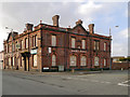
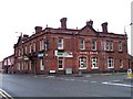
Rams Head
The former Rams Head public house at the corner of Church Road and Kenyon's Lane South, Haydock. Terracotta lettering on the side proclaims that it was "Rebuilt 1896".
Image: © David Dixon
Taken: 31 Jan 2013
0.11 miles
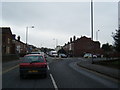
3
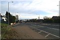
Junction and footbridge on the East Lancs Road
Image: © David Long
Taken: 25 Nov 2005
0.13 miles
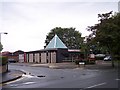
9
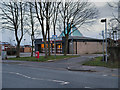
Haydock Library
The Village Library on Church Road.
Image: © David Dixon
Taken: 31 Jan 2013
0.23 miles