IMAGES TAKEN NEAR TO
Ravenhead Road, ST. HELENS, WA10 3LR
Introduction
This page details the photographs taken nearby to Ravenhead Road, WA10 3LR by members of the Geograph project.
The Geograph project started in 2005 with the aim of publishing, organising and preserving representative images for every square kilometre of Great Britain, Ireland and the Isle of Man.

There are currently over 7.5m images from over14,400 individuals and you can help contribute to the project by visiting https://www.geograph.org.uk
Image Map
Images are licensed for reuse under creativecommons.org/licenses/by-sa/2.0
Notes
- Clicking on the map will re-center to the selected point.
- The higher the marker number, the further away the image location is from the centre of the postcode.
Image Listing (19 Images Found)
Images are licensed for reuse under creativecommons.org/licenses/by-sa/2.0
Image
Details
Distance
1
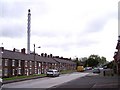
Factory Row
Terraced housing dominated by Pilkington's chimney
Image: © Raymond Knapman
Taken: 11 Aug 2010
0.01 miles
2
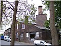
Ravenhead Windmill
This windmill was originally used to drive machinery at British Cast Plate Manufactury.The turret on top was used as WW2 lookout
Image: © Raymond Knapman
Taken: 11 Aug 2010
0.04 miles
3
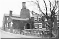
Ravenhead Windmill
Eighteenth century windmill on the edge of the former British Cast Plate Glass Manufactory at Ravenhead (now part of Pilkington). There were two windmills in the works in the 1810s, used to power machinery to grind emery and pump water used to polish slab-cast sheets of glass. They were later replaced by a Boulton and Watt steam engine. The tower of this one survives because it became a house and later part of a school. The turret on top is a WWII lookout. When the photo was taken it had become the "Dead Fly" recording studio.
Image: © Gareth Hughes
Taken: Unknown
0.05 miles
6
Path towards Elm Road from Alexandra Colliery
Image: © Gary Rogers
Taken: 23 Aug 2017
0.08 miles
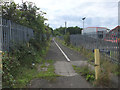
7
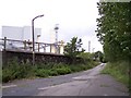
Remains of railway level crossing at Ravenhead
Few remains are left of what was an intesive railway system around the Pilkington sites
Image: © Raymond Knapman
Taken: 11 Aug 2010
0.08 miles
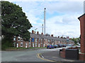
8
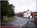
Elm Road joins Crossley Road at Thatto Heath Park
Image: © Raymond Knapman
Taken: 11 Aug 2010
0.10 miles
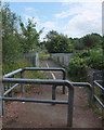
9
Path from Ravenhead Road to Alexandra Colliery
Image: © Gary Rogers
Taken: 23 Aug 2017
0.13 miles
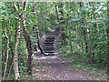
10
Bridge between Ravenhead Colliery and Thatto Heath
Image: © Gary Rogers
Taken: 23 Aug 2017
0.14 miles