IMAGES TAKEN NEAR TO
Woodfield Road, LONDON, W9 3XZ
Introduction
This page details the photographs taken nearby to Woodfield Road, W9 3XZ by members of the Geograph project.
The Geograph project started in 2005 with the aim of publishing, organising and preserving representative images for every square kilometre of Great Britain, Ireland and the Isle of Man.

There are currently over 7.5m images from over14,400 individuals and you can help contribute to the project by visiting https://www.geograph.org.uk
Image Map
Images are licensed for reuse under creativecommons.org/licenses/by-sa/2.0
Notes
- Clicking on the map will re-center to the selected point.
- The higher the marker number, the further away the image location is from the centre of the postcode.
Image Listing (349 Images Found)
Images are licensed for reuse under creativecommons.org/licenses/by-sa/2.0
Image
Details
Distance
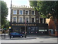
5

Westbourne Green, Windsor Castle
Closed public house on Harrow Road, whose future seems in doubt: http://www.maidahillforum.org.uk/our-campaigns/79-windsor-castle-update.html
Image: © Mike Faherty
Taken: 9 Apr 2016
0.04 miles
7
City of Westminster, One Stop Services
317 Harrow Road
Image: © Oxyman
Taken: 11 Sep 2009
0.06 miles
10
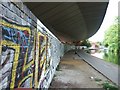
Underneath the A40 Westway
The towpath of the Grand Union Canal runs underneath the road, and the wall has been covered with graffiti.
Image: © David Smith
Taken: 21 May 2011
0.06 miles