IMAGES TAKEN NEAR TO
Chantry Close, LONDON, W9 3PZ
Introduction
This page details the photographs taken nearby to Chantry Close, W9 3PZ by members of the Geograph project.
The Geograph project started in 2005 with the aim of publishing, organising and preserving representative images for every square kilometre of Great Britain, Ireland and the Isle of Man.

There are currently over 7.5m images from over14,400 individuals and you can help contribute to the project by visiting https://www.geograph.org.uk
Image Map
Images are licensed for reuse under creativecommons.org/licenses/by-sa/2.0
Notes
- Clicking on the map will re-center to the selected point.
- The higher the marker number, the further away the image location is from the centre of the postcode.
Image Listing (328 Images Found)
Images are licensed for reuse under creativecommons.org/licenses/by-sa/2.0
Image
Details
Distance
6
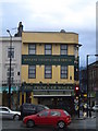
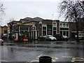
The Prince of Wales, Harrow Road W9
At the junction with Great Western Road - taken from the junction with Elgin Avenue
Image: © Robin Sones
Taken: 19 Oct 2010
0.05 miles
7
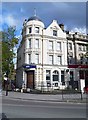
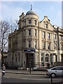
The Royal Bank of Scotland, 2 Elgin Avenue, Maida Vale, London
Local branch of the Royal Bank of Scotland which also owns NatWest Bank, Ulster Bank and various smaller banking organisations. Currently the majority stake in the whole organisation remains in UK Government hands after the massive state bailout following the financial crisis of 2008.
Image: © L S Wilson
Taken: 5 May 2015
0.06 miles
10
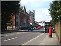
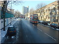
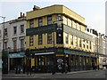
Looking west along Harrow Road at Westbourne Green
The building on the left is Harrow Road Police Station and looming in the background is the Trinnick Tower block of flats.
Image: © Rod Allday
Taken: 3 Sep 2011
0.06 miles