IMAGES TAKEN NEAR TO
Saltram Crescent, LONDON, W9 3HR
Introduction
This page details the photographs taken nearby to Saltram Crescent, W9 3HR by members of the Geograph project.
The Geograph project started in 2005 with the aim of publishing, organising and preserving representative images for every square kilometre of Great Britain, Ireland and the Isle of Man.

There are currently over 7.5m images from over14,400 individuals and you can help contribute to the project by visiting https://www.geograph.org.uk
Image Map
Images are licensed for reuse under creativecommons.org/licenses/by-sa/2.0
Notes
- Clicking on the map will re-center to the selected point.
- The higher the marker number, the further away the image location is from the centre of the postcode.
Image Listing (67 Images Found)
Images are licensed for reuse under creativecommons.org/licenses/by-sa/2.0
Image
Details
Distance
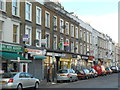
1
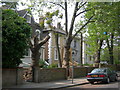
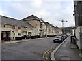
Malvern Road, NW6
The tree lined street and the large houses may look attractive, but this is the view from the front Image
Image: © Danny P Robinson
Taken: 29 Apr 2007
0.05 miles
2
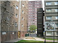
South Kilburn Estate
This picture was taken on Malvern Road. "Welcome to Dickens House", says the sign on the left. Austen House is through the walkway, Blake Court is to the right of the walkway. These flats, and many nearby, will be demolished soon for a much needed but controversial regeneration project. There was recently a police raid on this estate which recovered several guns and a significant quantity of crack cocaine, cash and other items. Links of interest are below..
http://society.guardian.co.uk/urbandesign/story/0,,870922,00.html
http://www.brent.gov.uk/filmloc.nsf/0/EC01CDBAC43C9E098025718700360098?OpenDocument
http://www.kilburntimes.co.uk/content/camden/kilburntimes/news/story.aspx?brand=KLBTOnline&category=news&tBrand=northlondon24&tCategory=newsklbt&itemid=WeED18%20Apr%202007%2014%3A58%3A22%3A777
Image: © Danny P Robinson
Taken: 29 Apr 2007
0.05 miles
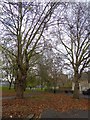
3
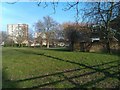
Recreation ground between Malvern Road and Carlton Vale
Image: © David Martin
Taken: 4 Mar 2013
0.08 miles
7
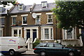
Houses in Shirland Road
I used to live in the one with the large white dish. However
the dish wasn't there 56 years ago. The house seemed so much
bigger when I was 6 years old.
Image: © Andy Pearce
Taken: 8 Jul 2009
0.12 miles
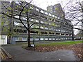
8
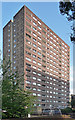
South Kilburn Estate, Cambridge Road
This, I think, is the bucolic Austen House. The estate was built up from 1959 - presumably for the London County Council - and includes a number of high-rise slabs which are now starting to come down as part of a comprehensive reinvention. There are strange little nodules on the end wall - presumably a then-trendy 1960s abstract motif.
Image: © Stephen Richards
Taken: 9 Jul 2011
0.12 miles
9
Modern houses, Stafford Road
Housing which deserves the tag: architectural interest
Image: © David Smith
Taken: 26 Nov 2015
0.13 miles
10
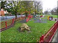
Play area, South Kilburn Open Space
The open space is a triangle of land to the south of Carlton Vale
Image: © David Smith
Taken: 26 Nov 2015
0.13 miles