IMAGES TAKEN NEAR TO
Kilburn Lane, LONDON, W9 3EF
Introduction
This page details the photographs taken nearby to Kilburn Lane, W9 3EF by members of the Geograph project.
The Geograph project started in 2005 with the aim of publishing, organising and preserving representative images for every square kilometre of Great Britain, Ireland and the Isle of Man.

There are currently over 7.5m images from over14,400 individuals and you can help contribute to the project by visiting https://www.geograph.org.uk
Image Map
Images are licensed for reuse under creativecommons.org/licenses/by-sa/2.0
Notes
- Clicking on the map will re-center to the selected point.
- The higher the marker number, the further away the image location is from the centre of the postcode.
Image Listing (128 Images Found)
Images are licensed for reuse under creativecommons.org/licenses/by-sa/2.0
Image
Details
Distance
2
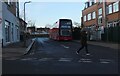
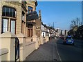
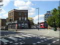
Claremont Road, Queens Park
This is used as a bus stand
Image: © David Howard
Taken: 25 Jan 2021
0.03 miles
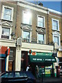
3
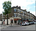
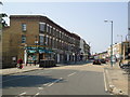
Kilburn Lane shops, London W9
The business on the corner of Kilburn Lane and Portnall Road is Cream, a cafe.
Image: © Jaggery
Taken: 13 May 2012
0.04 miles
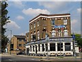
4
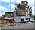
The Falcon, London W9
Mid-Victorian pub at 341 Kilburn Lane, near Queen's Park underground station.
Image: © Jaggery
Taken: 13 May 2012
0.04 miles
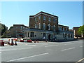
8
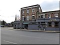
The Falcon Bar & Lounge
Closed since 2017.
Image: © Rod Allday
Taken: 21 May 2019
0.05 miles