IMAGES TAKEN NEAR TO
Lapford Close, LONDON, W9 3DW
Introduction
This page details the photographs taken nearby to Lapford Close, W9 3DW by members of the Geograph project.
The Geograph project started in 2005 with the aim of publishing, organising and preserving representative images for every square kilometre of Great Britain, Ireland and the Isle of Man.

There are currently over 7.5m images from over14,400 individuals and you can help contribute to the project by visiting https://www.geograph.org.uk
Image Map
Images are licensed for reuse under creativecommons.org/licenses/by-sa/2.0
Notes
- Clicking on the map will re-center to the selected point.
- The higher the marker number, the further away the image location is from the centre of the postcode.
Image Listing (209 Images Found)
Images are licensed for reuse under creativecommons.org/licenses/by-sa/2.0
Image
Details
Distance
1

Portnall Road and Trellick Tower
Looking along Portnall Road towards the distinctive Trellick Tower in the distance.
Image: © DS Pugh
Taken: 4 May 2019
0.07 miles
2
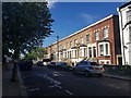
Along Portnall Road
Looking along Portnall Road in West Kilburn.
Image: © DS Pugh
Taken: 4 May 2019
0.08 miles

4

Through a gap in the houses on Shirland Road
Image: © Andrew Wilson
Taken: 8 Dec 2013
0.09 miles
5
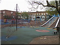
Children's Playground
Children's Playground on the corner of Shirland Road and Ashmore Road
Image: © Shaun Ferguson
Taken: 24 Apr 2008
0.10 miles


8

Mosaic wall close to Walterton Road Public Toilets
Image: © Oxyman
Taken: 15 Feb 2008
0.13 miles
9
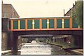
A pretty bridge on the Grand Union Canal.
The Harrow road runs approximately along the right hand side of this bridge.
Image: © Hazel
Taken: 26 Aug 1988
0.14 miles
10
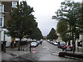
Fernhead Road W9
At the junction with Elgin Avenue
Image: © Robin Sones
Taken: 19 Oct 2010
0.14 miles