IMAGES TAKEN NEAR TO
Great Western Road, LONDON, W9 3BT
Introduction
This page details the photographs taken nearby to Great Western Road, W9 3BT by members of the Geograph project.
The Geograph project started in 2005 with the aim of publishing, organising and preserving representative images for every square kilometre of Great Britain, Ireland and the Isle of Man.

There are currently over 7.5m images from over14,400 individuals and you can help contribute to the project by visiting https://www.geograph.org.uk
Image Map
Images are licensed for reuse under creativecommons.org/licenses/by-sa/2.0
Notes
- Clicking on the map will re-center to the selected point.
- The higher the marker number, the further away the image location is from the centre of the postcode.
Image Listing (361 Images Found)
Images are licensed for reuse under creativecommons.org/licenses/by-sa/2.0
Image
Details
Distance
1
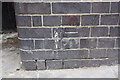
Benchmark on Big Table showrooms, #56 Great Western Road
Ordnance Survey cut mark benchmark described on the Bench Mark Database at http://www.bench-marks.org.uk/bm37821
Image: © Roger Templeman
Taken: 13 May 2011
0.00 miles
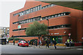
2
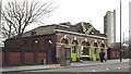
"The Big Table", Westbourne Park
If this looks like a railway building, that's because it is. Built in 1901 as a coffee house for railway workers, the building is now a furniture shop. The Victorian Society website gives more information about this building and its history: http://www.victoriansociety.org.uk/news/historic-london-coffee-house-under-threat-from-crossrail/
In the background is Trellick Tower, a 31-storey block of flats designed by the architect Ernő Goldfinger and completed in 1972.
Image: © Malc McDonald
Taken: 23 Feb 2014
0.00 miles
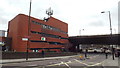
3
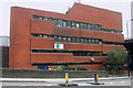
Westbourne Park bus garage
This part of the garage houses offices and various staff facilities. The buses themselves are kept under cover in the area to the right of these buildings. Just visible on the far right is Westway, the elevated section of the A40 which here provides a roof for part of the garage. Westbourne Park was opened in 1981 by London Transport and replaced a very cramped facility at Middle Row, North Kensington and a former trolleybus depot a few miles up the Harrow Road at Stonebridge.
Image: © David Kemp
Taken: 11 Nov 2015
0.02 miles
4
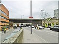
Westbourne Green, flyover
Carrying Westway (A40[M]) over Great Western Road.
Image: © Mike Faherty
Taken: 9 Apr 2016
0.02 miles
5
Westbourne Park bus garage
Westbourne Park bus garage opened in 1981. The flyover carrying the A40 trunk road forms part of the bus garage roof.
Image: © Malc McDonald
Taken: 23 Feb 2014
0.02 miles
6
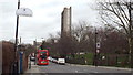
Elkstone Road, Westbourne Park
Elkstone Road in Westbourne Park. In the background is Trellick Tower, a 31-storey tower block designed by architect Ernő Goldfinger and completed in 1972.
Image: © Malc McDonald
Taken: 23 Feb 2014
0.02 miles
7
Westbourne Park bus garage - public entrance
Westway, the elevated section of the A40 built between 1964-70, can be seen in the top right-hand corner. When the garage opened in 1981 Westway no longer just carried traffic but served here as part of the garage roof.
Image: © David Kemp
Taken: 10 Oct 2015
0.03 miles
8
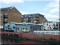
Canalside pub at Notting Hill Carnival time
The Grand Union public house is on the edge of Notting Hill, and in the photo has a steel band performer on a platform suspended over the canal to make the most of their limited outside space.
Image: © David Hawgood
Taken: 23 Aug 2008
0.03 miles
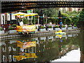
9
Lock-up garages by the Grand Union Canal
Perhaps someone knows the use of these; it looks as if they are a base for London hackney cabs.
Image: © David Smith
Taken: 21 May 2011
0.03 miles
10

Westbourne Park bus garage
Westbourne Park garage was opened by London Transport in 1981 and is now owned by Tower Transit who purchased it (and others) from First Group in 2013. This picture was taken of the bus parking area from the top-deck of another bus on the occasion of the Garage Open Day which explains the presence of the three vintage buses in the middle. The blue-painted bridge crosses the Grand Union Canal and the houses beyond it are in Woodfield Road.
Image: © David Kemp
Taken: 10 Oct 2015
0.03 miles