IMAGES TAKEN NEAR TO
Sutherland Avenue, LONDON, W9 2QR
Introduction
This page details the photographs taken nearby to Sutherland Avenue, W9 2QR by members of the Geograph project.
The Geograph project started in 2005 with the aim of publishing, organising and preserving representative images for every square kilometre of Great Britain, Ireland and the Isle of Man.

There are currently over 7.5m images from over14,400 individuals and you can help contribute to the project by visiting https://www.geograph.org.uk
Image Map
Images are licensed for reuse under creativecommons.org/licenses/by-sa/2.0
Notes
- Clicking on the map will re-center to the selected point.
- The higher the marker number, the further away the image location is from the centre of the postcode.
Image Listing (192 Images Found)
Images are licensed for reuse under creativecommons.org/licenses/by-sa/2.0
Image
Details
Distance
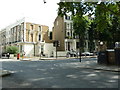
1
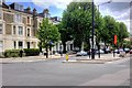
Maida Vale, Sutherland Avenue
Maida Vale is a residential district comprising the northern part of Paddington in west London.
Image: © David Dixon
Taken: 30 May 2015
0.00 miles
2
Vent pipe for the (lost) River Westbourne on Sutherland Avenue
I believe that this is a vent for the pipe through which the River Westbourne was diverted in 1850, during the building of Maida Vale.
Image: © John Andrew
Taken: 14 Sep 2008
0.03 miles
3
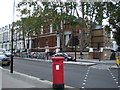
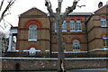
Public Library on Sutherland Avenue
The Maida Vale Public Library is on the corner of Sutherland Avenue and Shirland Road.
It has recently been modernised inside, but before this modernisation it held the criminology department of the British Library on the first floor (around the current balcony area).
One other odd fact about it is that it doubled as the police station in the 1980s ITV series, Minder, improvised by simply placing a "Police" sign on the gatepost.
Image: © John Andrew
Taken: 14 Sep 2008
0.03 miles
4
Shirland Road, Maida Hill
Looking towards Sutherland Avenue
Image: © David Howard
Taken: 20 Jan 2022
0.04 miles
5
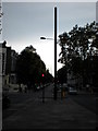
Junction of Sutherland Avenue and Shirland Road W9
Image: © Alexander P Kapp
Taken: 20 Jul 2012
0.05 miles
6
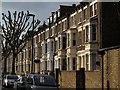
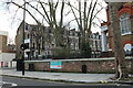
Shirland Road
A terrace on the north-east side of the road, seen from the junction with Sutherland Avenue.
Image: © Derek Harper
Taken: 15 Apr 2010
0.05 miles
7
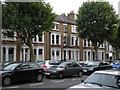
Terraced housing in Maida Vale
While most of the buildings in the Maida Vale and Maida Hill areas of London were built as flats (known locally as "mansion blocks"), some terraces were built with whole houses. Since then most of these have now been converted into flats.
Image: © John Andrew
Taken: 14 Sep 2008
0.05 miles
8
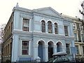
Amadeus Centre, W9
Occupying a renovated 19th century Welsh Presbyterian chapel, the Amadeus Centre, on the corner of Shirland Road and Braden Street, is now an events and wedding venue.
Image: © Derek Harper
Taken: 12 Mar 2011
0.05 miles
10
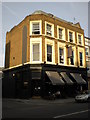
Public house on Shirland Road
The pub is now a gastropub/bar, called "Idlewild". For many years it was a traditional local pub, called "The Truscott Arms".
Image: © John Andrew
Taken: 14 Sep 2008
0.06 miles