IMAGES TAKEN NEAR TO
Warwick Place, LONDON, W9 2PX
Introduction
This page details the photographs taken nearby to Warwick Place, W9 2PX by members of the Geograph project.
The Geograph project started in 2005 with the aim of publishing, organising and preserving representative images for every square kilometre of Great Britain, Ireland and the Isle of Man.

There are currently over 7.5m images from over14,400 individuals and you can help contribute to the project by visiting https://www.geograph.org.uk
Image Map
Images are licensed for reuse under creativecommons.org/licenses/by-sa/2.0
Notes
- Clicking on the map will re-center to the selected point.
- The higher the marker number, the further away the image location is from the centre of the postcode.
Image Listing (643 Images Found)
Images are licensed for reuse under creativecommons.org/licenses/by-sa/2.0
Image
Details
Distance
1
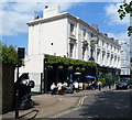
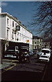
The Warwick Castle, London W9
Pub in Warwick Place, between Blomfield Road and Warwick Avenue.
Image: © Jaggery
Taken: 13 May 2012
0.00 miles
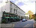
2
Public house on Warwick Place
The Warwick Castle pub on Warwick Place
Image: © John Andrew
Taken: 14 Sep 2008
0.00 miles
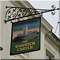
3
The 'Warwick Castle', just off Blomfield Road. London W9
They've clearly made an effort to make customers feel at ease in Covid times. And I don't remember hanging baskets in the days when I used to meet friends here.
The pub faces south-east, so bright low sun on a November afternoon made for tricky photographic conditions.
Image: © Stefan Czapski
Taken: 2 Nov 2021
0.01 miles
5
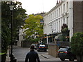
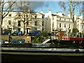
Warwick Place
A narrow side street connecting Warwick Avenue with Blomfield Road. The small parade of shops was mainly antiques and art, though there was a restaurant. The Warwick Castle was a Charringtons house but subsequently became a free house. In the foreground is rag-and-bone man's Horse and cart, unfortunately not well captured due to the extreme contrast in the photo.
Image: © Martin Addison
Taken: Unknown
0.02 miles
6
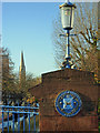
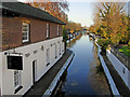
Westbourne Terrace Road Bridge
This bridge carries Westbourne Terrace Road across the Grand Union Canal, just west of Little Venice. The plaque was erected by the Metropolitan Borough of Paddington which existed from 1900 until 1965 when it was absorbed into the City of Westminster in the reorganisation of London's local government that created the Greater London Council and abolished Middlesex. Despite this, the plaque has been maintained; the blue background comes from the arms of Paddington's first mayor, Sir John Aired, and it appears that this theme has been carried over to the bridge railings. The spire in the background belongs to St Mary Magdalene Church.
Image: © Stephen McKay
Taken: 23 Nov 2007
0.02 miles
10
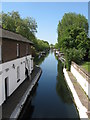
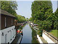
Grand Union Canal, Paddington
Seen from Westbourne Terrace Road Bridge, just west of Little Venice.
Image: © Stephen McKay
Taken: 23 Nov 2007
0.04 miles