IMAGES TAKEN NEAR TO
Widley Road, LONDON, W9 2LF
Introduction
This page details the photographs taken nearby to Widley Road, W9 2LF by members of the Geograph project.
The Geograph project started in 2005 with the aim of publishing, organising and preserving representative images for every square kilometre of Great Britain, Ireland and the Isle of Man.

There are currently over 7.5m images from over14,400 individuals and you can help contribute to the project by visiting https://www.geograph.org.uk
Image Map
Images are licensed for reuse under creativecommons.org/licenses/by-sa/2.0
Notes
- Clicking on the map will re-center to the selected point.
- The higher the marker number, the further away the image location is from the centre of the postcode.
Image Listing (68 Images Found)
Images are licensed for reuse under creativecommons.org/licenses/by-sa/2.0
Image
Details
Distance
1
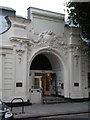
Detail of Maida Vale Studios
The main entrance to Maida Vale Studios on Delaware Road in Maida Vale, London W9.
Image: © John Andrew
Taken: 14 Sep 2008
0.04 miles
2
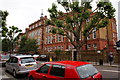
Essendine School
This is Essendine Junior School on Essendine Road.
This was the first school that I attended.
Image: © Andy Pearce
Taken: 8 Jul 2009
0.05 miles
3
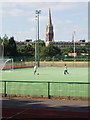
Paddington Recreation Ground and St Augustine's Church, Kilburn
This is a residential area with many blocks of flats. The large church was built 1871 to 1898.
Image: © David Hawgood
Taken: 26 Jun 2005
0.07 miles
4

Mansion flats in Maida Vale
In this area are many blocks of flats with "mansions" in their names.
Image: © David Hawgood
Taken: 26 Jun 2005
0.07 miles

6
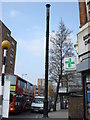
Mysterious cast iron column
This cast iron column stands on Kilburn Park road close to its beginning (or end) where it joins Shirland Road. At first I thought it was a supporting column for a former tram systems electricity wires, but I believe it to be too high. (A double decker bus can be seen next to it.) It appears to be of Victorian age, any further information on this would be appreciated
Update: It seems that this is a sewer or tube vent pipe, for a discussion about these go here http://www.geograph.org.uk/discuss/index.php?&action=vthread&forum=2&topic=1878&page=0
http://www.geograph.org.uk/discuss/index.php?&action=vthread&forum=2&topic=1878&page=0
Thanks to Penny Mayes and Silk for this information
Image: © Oxyman
Taken: 16 Apr 2007
0.07 miles
8
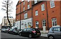
Elgin Avenue, Maida Hill
The junction with Shirland Road is just on the left
Image: © David Howard
Taken: 15 Jan 2009
0.08 miles
9
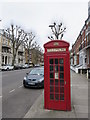
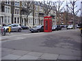
Telephone box on Elgin Avenue
Not listed.
Image: © David Anstiss
Taken: 8 Mar 2015
0.09 miles
10
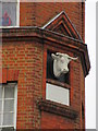
Cow head detail of Warrick Farm Dairy
See Image for large photo of the former Dairy.
Image: © David Anstiss
Taken: 8 Mar 2015
0.09 miles