IMAGES TAKEN NEAR TO
Amberley Road, LONDON, W9 2JJ
Introduction
This page details the photographs taken nearby to Amberley Road, W9 2JJ by members of the Geograph project.
The Geograph project started in 2005 with the aim of publishing, organising and preserving representative images for every square kilometre of Great Britain, Ireland and the Isle of Man.

There are currently over 7.5m images from over14,400 individuals and you can help contribute to the project by visiting https://www.geograph.org.uk
Image Map
Images are licensed for reuse under creativecommons.org/licenses/by-sa/2.0
Notes
- Clicking on the map will re-center to the selected point.
- The higher the marker number, the further away the image location is from the centre of the postcode.
Image Listing (231 Images Found)
Images are licensed for reuse under creativecommons.org/licenses/by-sa/2.0
Image
Details
Distance
1
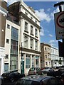
The Earl of Derby (former inn)
The name is inscribed on the facade at the top, on the third floor. Like many buildings of the late 19th and early 20th centuries, the builders never envisaged a change of use. The inscription is in
Image]
Image: © David Smith
Taken: 21 May 2011
0.02 miles
2
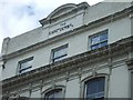
Inscription on Earl of Derby (former inn)
The building is shown in Image]
Image: © David Smith
Taken: 21 May 2011
0.02 miles
4
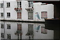
Regents Canal by 324 Harrow Road
Image: © Oast House Archive
Taken: 21 Dec 2017
0.02 miles


8
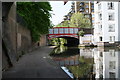
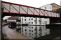
Harrow Road Bridge 3, Paddington Arm, Grand Union Canal
Looking west.
Image: © Dr Neil Clifton
Taken: 8 May 2008
0.03 miles
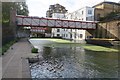
10
Enclosed bridge 3A Paddington Arm - cables?
Although this bridge is shown on Ordnance Survey 1:25,000 and larger scale maps as a footbridge, there is no access either into Westbourne Green shown in the photo, nor to the towpath this side. I believe it carries National Grid high voltage cables - which run beneath the towpath.
Image: © David Hawgood
Taken: 15 Dec 2011
0.03 miles