IMAGES TAKEN NEAR TO
Harrow Road, LONDON, W9 2HX
Introduction
This page details the photographs taken nearby to Harrow Road, W9 2HX by members of the Geograph project.
The Geograph project started in 2005 with the aim of publishing, organising and preserving representative images for every square kilometre of Great Britain, Ireland and the Isle of Man.

There are currently over 7.5m images from over14,400 individuals and you can help contribute to the project by visiting https://www.geograph.org.uk
Image Map
Images are licensed for reuse under creativecommons.org/licenses/by-sa/2.0
Notes
- Clicking on the map will re-center to the selected point.
- The higher the marker number, the further away the image location is from the centre of the postcode.
Image Listing (321 Images Found)
Images are licensed for reuse under creativecommons.org/licenses/by-sa/2.0
Image
Details
Distance
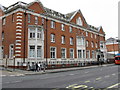
1
City of Westminster, One Stop Services
317 Harrow Road
Image: © Oxyman
Taken: 11 Sep 2009
0.01 miles
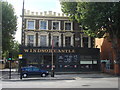
3

Westbourne Green, Windsor Castle
Closed public house on Harrow Road, whose future seems in doubt: http://www.maidahillforum.org.uk/our-campaigns/79-windsor-castle-update.html
Image: © Mike Faherty
Taken: 9 Apr 2016
0.02 miles
7
Metropolitan Police Station, Harrow Road
Image: © Peter Whatley
Taken: 27 May 2009
0.05 miles
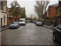
8
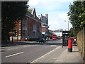
Looking west along Harrow Road at Westbourne Green
The building on the left is Harrow Road Police Station and looming in the background is the Trinnick Tower block of flats.
Image: © Rod Allday
Taken: 3 Sep 2011
0.06 miles