IMAGES TAKEN NEAR TO
Maida Vale, LONDON, W9 1SH
Introduction
This page details the photographs taken nearby to Maida Vale, W9 1SH by members of the Geograph project.
The Geograph project started in 2005 with the aim of publishing, organising and preserving representative images for every square kilometre of Great Britain, Ireland and the Isle of Man.

There are currently over 7.5m images from over14,400 individuals and you can help contribute to the project by visiting https://www.geograph.org.uk
Image Map
Images are licensed for reuse under creativecommons.org/licenses/by-sa/2.0
Notes
- Clicking on the map will re-center to the selected point.
- The higher the marker number, the further away the image location is from the centre of the postcode.
Image Listing (318 Images Found)
Images are licensed for reuse under creativecommons.org/licenses/by-sa/2.0
Image
Details
Distance
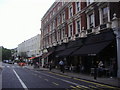
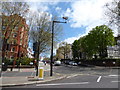
2
Slow, slow, quick, quick, slower (120)
Junction of Clifton Road and Maida Vale
Image: © Basher Eyre
Taken: 23 Apr 2016
0.02 miles
3
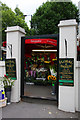
Floral & Hardy
An open air florists on Clifton Road.
Image: © Martin Addison
Taken: 1 Aug 2008
0.03 miles
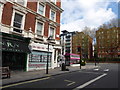
4
St. John's Wood Road
Junction with Maida Vale.
Image: © Peter Barr
Taken: 2 Nov 2011
0.03 miles
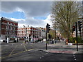
5
Slow, slow, quick, quick, slower (121)
Junction of Maida Vale and St John's Wood Road
Image: © Basher Eyre
Taken: 23 Apr 2016
0.03 miles
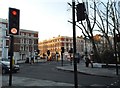
6
Slow, slow, quick, quick, slower (122)
Junction of St John's Wood Road and Maida Vale
Image: © Basher Eyre
Taken: 23 Apr 2016
0.03 miles

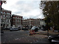
9
St Johns Wood Road at the junction of Maida Vale
Image: © David Howard
Taken: 19 Jan 2017
0.03 miles
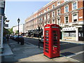
10

The sign for the Robert Browning public house
A Sam Smith's pub in London
Image: © Ian S
Taken: 8 Dec 2010
0.03 miles