IMAGES TAKEN NEAR TO
Lanark Mews, LONDON, W9 1RY
Introduction
This page details the photographs taken nearby to Lanark Mews, W9 1RY by members of the Geograph project.
The Geograph project started in 2005 with the aim of publishing, organising and preserving representative images for every square kilometre of Great Britain, Ireland and the Isle of Man.

There are currently over 7.5m images from over14,400 individuals and you can help contribute to the project by visiting https://www.geograph.org.uk
Image Map
Images are licensed for reuse under creativecommons.org/licenses/by-sa/2.0
Notes
- Clicking on the map will re-center to the selected point.
- The higher the marker number, the further away the image location is from the centre of the postcode.
Image Listing (154 Images Found)
Images are licensed for reuse under creativecommons.org/licenses/by-sa/2.0
Image
Details
Distance
2
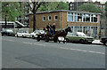
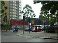
Any Old Iron!
On Sutherland Avenue, the rag and bone man passes St. Joseph's RC primary school. The school itself is on Lanark Road.
Image: © Martin Addison
Taken: Unknown
0.03 miles
4

Esso petrol station on Sutherland Avenue, Maida Vale
Image: © David Howard
Taken: 20 Jan 2022
0.04 miles
5

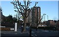
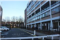
Stuart Tower, Maida Vale
The main entrance is on Maida Vale
Image: © David Howard
Taken: 20 Jan 2022
0.04 miles
6
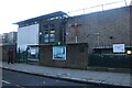
St Joseph's Catholic Primary School, Maida Vale
Image: © David Howard
Taken: 25 Jan 2021
0.05 miles
7
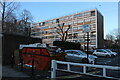
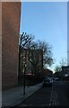
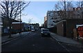
Housing estate by Lanark Road, Maida Vale
Image: © David Howard
Taken: 25 Jan 2021
0.05 miles
9
Housing estate by Lanark Road, Maida Vale
Fronting onto Maida Vale behind
Image: © David Howard
Taken: 25 Jan 2021
0.05 miles
10
Sutherland Avenue and Maida Vale, W9
With Everyman Cinema in the background
Image: © Alexander P Kapp
Taken: 16 Jul 2012
0.05 miles