IMAGES TAKEN NEAR TO
Maida Vale, LONDON, W9 1QP
Introduction
This page details the photographs taken nearby to Maida Vale, W9 1QP by members of the Geograph project.
The Geograph project started in 2005 with the aim of publishing, organising and preserving representative images for every square kilometre of Great Britain, Ireland and the Isle of Man.

There are currently over 7.5m images from over14,400 individuals and you can help contribute to the project by visiting https://www.geograph.org.uk
Image Map
Images are licensed for reuse under creativecommons.org/licenses/by-sa/2.0
Notes
- Clicking on the map will re-center to the selected point.
- The higher the marker number, the further away the image location is from the centre of the postcode.
Image Listing (194 Images Found)
Images are licensed for reuse under creativecommons.org/licenses/by-sa/2.0
Image
Details
Distance
1
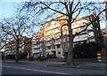
Flats on Maida Vale
Named after the Hero of Maida Inn, from a battle in Italy http://www.british-history.ac.uk/vch/middx/vol9/pp212-217
Image: © David Howard
Taken: 19 Jan 2017
0.02 miles
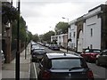
3
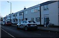
Terrace of houses on Lanark Road, Maida Vale
These are typical of the style of the 1960s.
Image: © David Howard
Taken: 25 Jan 2021
0.04 miles
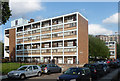
4
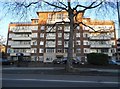
Wellesley Court, Maida Vale
Lord Wellesley was the Duke of Wellington, also named in the parallel Wellington Road leading to Finchley.
Image: © David Howard
Taken: 19 Jan 2017
0.04 miles

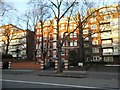
7
Maida Vale Estate, Lanark Road (2)
A London County Council estate, dating from 1959-64, strung out along the road in a series of towers (Image]) and low-rise blocks, the latter with "balconies in alternate floors to ... reduce the monolithic effect".
Image: © Stephen Richards
Taken: 9 Jul 2011
0.05 miles
9
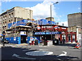
Maida Vale Underground Station undergoing renovation
Maida Vale opened on 6 June 1915 on the Bakerloo Line's extension from Paddington station to Queen's Park, although services had been running non-stop through the incomplete station to Kilburn Park since 31 January 1915 and to Queen's Park from 11 February 1915. The station is located at the junction of Elgin Avenue and Randolph Avenue and for a time prior to its opening the proposed name for the station was Elgin Avenue.
The station building, designed by the Underground Group's architect Stanley A Heaps, was constructed in a modified style of the earlier Leslie Green designed Bakerloo Line stations with glazed terra cotta façades.
Image: © Oxyman
Taken: 29 Jun 2007
0.05 miles
10
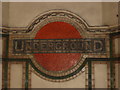
Underground Mosaic
This mosaic is just inside the entrance to Maida Vale Underground Station.
Image: © Oxyman
Taken: 8 Mar 2007
0.05 miles