IMAGES TAKEN NEAR TO
Maida Vale, LONDON, W9 1QG
Introduction
This page details the photographs taken nearby to Maida Vale, W9 1QG by members of the Geograph project.
The Geograph project started in 2005 with the aim of publishing, organising and preserving representative images for every square kilometre of Great Britain, Ireland and the Isle of Man.

There are currently over 7.5m images from over14,400 individuals and you can help contribute to the project by visiting https://www.geograph.org.uk
Image Map
Images are licensed for reuse under creativecommons.org/licenses/by-sa/2.0
Notes
- Clicking on the map will re-center to the selected point.
- The higher the marker number, the further away the image location is from the centre of the postcode.
Image Listing (265 Images Found)
Images are licensed for reuse under creativecommons.org/licenses/by-sa/2.0
Image
Details
Distance
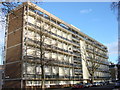
1
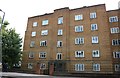
Flats on Maida Vale
This makes up about a quarter of the whole block which repeats the design along the single row of blocks.
Image: © David Howard
Taken: 3 Oct 2019
0.03 miles
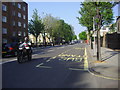
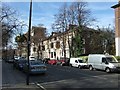
3
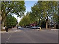
Kilburn High Road
Looking along Kilburn High Road from Maida Vale at the junction with Carlton Vale.
Image: © DS Pugh
Taken: 5 May 2019
0.03 miles

9
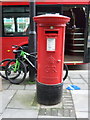
George V postbox on Maida Vale, London W9
Postbox No. W9 17.
See Image] for context.
Image: © JThomas
Taken: 18 Mar 2017
0.05 miles
10
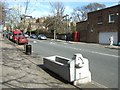
Horse trough and drinking fountain in Carlton Hill
Image: © David Smith
Taken: 24 Mar 2011
0.06 miles