IMAGES TAKEN NEAR TO
Randolph Avenue, LONDON, W9 1NP
Introduction
This page details the photographs taken nearby to Randolph Avenue, W9 1NP by members of the Geograph project.
The Geograph project started in 2005 with the aim of publishing, organising and preserving representative images for every square kilometre of Great Britain, Ireland and the Isle of Man.

There are currently over 7.5m images from over14,400 individuals and you can help contribute to the project by visiting https://www.geograph.org.uk
Image Map
Images are licensed for reuse under creativecommons.org/licenses/by-sa/2.0
Notes
- Clicking on the map will re-center to the selected point.
- The higher the marker number, the further away the image location is from the centre of the postcode.
Image Listing (228 Images Found)
Images are licensed for reuse under creativecommons.org/licenses/by-sa/2.0
Image
Details
Distance
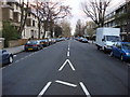
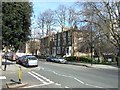
2
Carlton Vale at the junction of Randolph Avenue
Image: © David Howard
Taken: 25 Jan 2021
0.06 miles
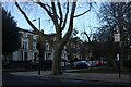
3
Carlton Vale at the junction of Randolph Avenue
Image: © David Howard
Taken: 25 Jan 2021
0.06 miles
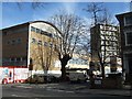
4
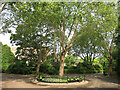
Paddington Recreation Ground, Est'd 1893
The earliest public athletic ground of its kind in London.
Still the largest area of parkland within the City of Westminster, it was opened in 1893 as recorded on this mini roundabout.
Image: © Des Blenkinsopp
Taken: 8 Jun 2016
0.06 miles
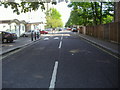
5

Carton Vale
Looking along Carlton Vale near the entrance to Paddington Recreation Ground.
Image: © DS Pugh
Taken: 5 May 2019
0.07 miles
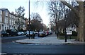
6
Carlton Vale
In the distance is the curved roof of St George's Catholic School
Image: © David Smith
Taken: 24 Mar 2011
0.07 miles
7

Flower bed, Paddington Recreation Ground
Image: © Tim Glover
Taken: 20 Apr 2018
0.07 miles
8
St George's Catholic School
The school was surrounded by protective hoarding as the site was being extended.
Image: © David Smith
Taken: 24 Mar 2011
0.07 miles
10
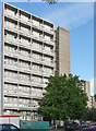
Maida Vale Estate, Lanark Road (1)
A London County Council estate, dating from 1959-64, strung out along the road in a series of towers and low-rise blocks (Image]), the former "successfully angled so as to make them appear less bulky".
Image: © Stephen Richards
Taken: 9 Jul 2011
0.08 miles