IMAGES TAKEN NEAR TO
Lauderdale Road, LONDON, W9 1LT
Introduction
This page details the photographs taken nearby to Lauderdale Road, W9 1LT by members of the Geograph project.
The Geograph project started in 2005 with the aim of publishing, organising and preserving representative images for every square kilometre of Great Britain, Ireland and the Isle of Man.

There are currently over 7.5m images from over14,400 individuals and you can help contribute to the project by visiting https://www.geograph.org.uk
Image Map
Images are licensed for reuse under creativecommons.org/licenses/by-sa/2.0
Notes
- Clicking on the map will re-center to the selected point.
- The higher the marker number, the further away the image location is from the centre of the postcode.
Image Listing (153 Images Found)
Images are licensed for reuse under creativecommons.org/licenses/by-sa/2.0
Image
Details
Distance
2
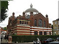
Lauderdale Road Synagogue, Maida Vale
The Maida Vale synagogue, at the junction of Lauderdale Road and Ashworth roads, is called Sha'ar Hashamayim but is referred to as "Lauderdale Road". It is one of three synagogues (the others are in the City of London and Wembley of the Spanish & Portuguese Jews' Congregation (an orthodox Sephardi congregation). The congregation was founded in the City of London over 300 years ago by a community that had escaped the Inquisition to Amsterdam. Some of its members settled in London when Oliver Cromwell set aside laws banning Jews from living in England. The building is Grade II listed.http://www.lauderdaleroadsynagogue.org/html/home.asp
Image: © Richard Rogerson
Taken: 8 Jul 2010
0.02 miles
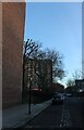
3
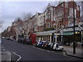
Junction of Sutherland Avenue, Randolph Avenue, Lauderdale Road and Warrington Terrace
Image: © Richard Rogerson
Taken: 8 Jul 2010
0.03 miles
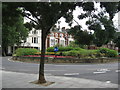
5
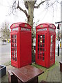
Pair of K2 Telephone Boxes outside Warrington Hotel
This pair of Grade II boxes is in the pub garden of the Hotel on the junction of Randolph Avenue and Warrington Crescent.
Image: © David Anstiss
Taken: 8 Mar 2015
0.04 miles
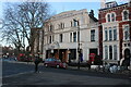
7
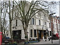
Warrington Hotel
Large Grade II listed hotel on the junction of Warrington Crescent and Sutherland Avenue.
Also has several K2 listed telephone boxes outside.
See http://www.britishlistedbuildings.co.uk/en-207461-warrington-hotel-greater-london-authorit for more details about the building.
Image: © David Anstiss
Taken: 8 Mar 2015
0.05 miles
8
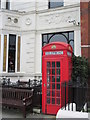
K2 Telephone Box outside Warrington Hotel
A Grade II listed box.
See http://www.britishlistedbuildings.co.uk/en-506441-k2-telephone-kiosk-outside-the-warringto for more details about the box.
Image: © David Anstiss
Taken: 8 Mar 2015
0.05 miles
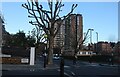
10
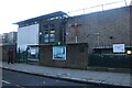
St Joseph's Catholic Primary School, Maida Vale
Image: © David Howard
Taken: 25 Jan 2021
0.07 miles