IMAGES TAKEN NEAR TO
Elgin Avenue, LONDON, W9 1JG
Introduction
This page details the photographs taken nearby to Elgin Avenue, W9 1JG by members of the Geograph project.
The Geograph project started in 2005 with the aim of publishing, organising and preserving representative images for every square kilometre of Great Britain, Ireland and the Isle of Man.

There are currently over 7.5m images from over14,400 individuals and you can help contribute to the project by visiting https://www.geograph.org.uk
Image Map
Images are licensed for reuse under creativecommons.org/licenses/by-sa/2.0
Notes
- Clicking on the map will re-center to the selected point.
- The higher the marker number, the further away the image location is from the centre of the postcode.
Image Listing (86 Images Found)
Images are licensed for reuse under creativecommons.org/licenses/by-sa/2.0
Image
Details
Distance
1
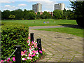
Paddington Recreation Ground
Taken from close to the bandstand towards the cricket ground.
Image: © Stephen McKay
Taken: 8 Aug 2007
0.08 miles
2
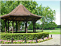
Bandstand, Paddington Recreation Ground
Paddington Recreation Ground has a wide range of sporting facilities including a running track, tennis courts, a cricket ground and a bowling green; there is still room, however, for the mainstay of any municipal park, a bandstand.
Image: © Stephen McKay
Taken: 8 Aug 2007
0.08 miles
3
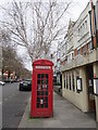
K2 Phone box on Lauderdale Road
This Grade II listed box is outside 1a, also La Cocchonnet restaurant.
See http://www.britishlistedbuildings.co.uk/en-413723-k2-telephone-kiosk-outside-number-1a-gre for more details about the box.
For some reason, the business still has its Xmas lights outside!
Image: © David Anstiss
Taken: 8 Mar 2015
0.10 miles
5
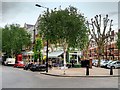
Maida Vale, Lauderdale Avenue
Maida Vale is a residential district comprising the northern part of Paddington in west London.
Image: © David Dixon
Taken: 30 May 2015
0.10 miles
6
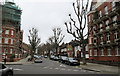
Biddulph Road
As seen from Lauderdale Road.
Image: © David Anstiss
Taken: 8 Mar 2015
0.11 miles
7
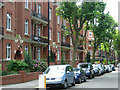
Grantully Road, Maida Vale
The block on the left is Ashworth Mansions; it overlooks Paddington Recreation Ground.
Image: © Stephen McKay
Taken: 8 Aug 2007
0.11 miles
8
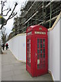
K2 phone box on Elgin Road
This listed telephone box is outside the former Paddington and Maida Vale Girls' High School.
Image: © David Anstiss
Taken: 8 Mar 2015
0.12 miles
9
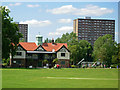
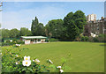
Paddington Recreation Ground
Paddington Recreation Ground, actually in Maida Vale, was saved for public use in the 19th century as the surrounding land was built up. Today it is administered by City of Westminster Council and incorporates facilities for a wide variety of sports. This area in front of the pavilion, called the Village Green, has an (artificial) cricket pitch.
Image: © Stephen McKay
Taken: 8 Aug 2007
0.12 miles
10
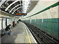
Maida Vale Underground Station
This is the southbound platform undergoing renovation
Image: © Oxyman
Taken: 13 Apr 2007
0.12 miles