IMAGES TAKEN NEAR TO
W9 1FX
Introduction
This page details the photographs taken nearby to W9 1FX by members of the Geograph project.
The Geograph project started in 2005 with the aim of publishing, organising and preserving representative images for every square kilometre of Great Britain, Ireland and the Isle of Man.

There are currently over 7.5m images from over14,400 individuals and you can help contribute to the project by visiting https://www.geograph.org.uk
Image Map
Images are licensed for reuse under creativecommons.org/licenses/by-sa/2.0
Notes
- Clicking on the map will re-center to the selected point.
- The higher the marker number, the further away the image location is from the centre of the postcode.
Image Listing (76 Images Found)
Images are licensed for reuse under creativecommons.org/licenses/by-sa/2.0
Image
Details
Distance
2
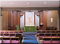
St Peter, Elgin Avenue, Paddington, London W9 - East end
Image: © John Salmon
Taken: 2 Sep 2007
0.05 miles
3
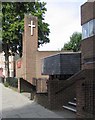
St Peter, Elgin Avenue, Paddington, London W9
Image: © John Salmon
Taken: 2 Sep 2007
0.05 miles
4
St Peter, Elgin Avenue, Paddington, London W9
Image: © John Salmon
Taken: 2 Sep 2007
0.05 miles
6
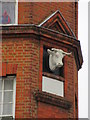
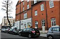
Cow head detail of Warrick Farm Dairy
See Image for large photo of the former Dairy.
Image: © David Anstiss
Taken: 8 Mar 2015
0.06 miles