IMAGES TAKEN NEAR TO
Randolph Avenue, LONDON, W9 1DN
Introduction
This page details the photographs taken nearby to Randolph Avenue, W9 1DN by members of the Geograph project.
The Geograph project started in 2005 with the aim of publishing, organising and preserving representative images for every square kilometre of Great Britain, Ireland and the Isle of Man.

There are currently over 7.5m images from over14,400 individuals and you can help contribute to the project by visiting https://www.geograph.org.uk
Image Map
Images are licensed for reuse under creativecommons.org/licenses/by-sa/2.0
Notes
- Clicking on the map will re-center to the selected point.
- The higher the marker number, the further away the image location is from the centre of the postcode.
Image Listing (150 Images Found)
Images are licensed for reuse under creativecommons.org/licenses/by-sa/2.0
Image
Details
Distance
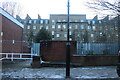
1
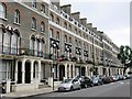
Randolph Avenue, W9
The east side, southeast of Image
Image: © Mike Quinn
Taken: 20 Aug 2015
0.02 miles
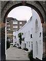
2
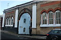
The entrance to Elgin Mews South, Maida Vale
Image: © David Howard
Taken: 25 Jan 2021
0.04 miles
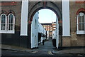
4
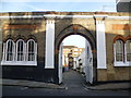
Entrance to Elgin Mews South
This facade is immediately next to Maida Vale Tube which is just to the left out of the picture - see http://www.geograph.org.uk/photo/3747408
Image: © Marathon
Taken: 13 Nov 2013
0.04 miles
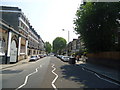
5
Lanark Road looking towards Randolph Avenue
Image: © David Howard
Taken: 25 Jan 2021
0.04 miles
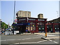
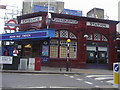
6
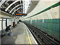
Maida Vale Underground Station
This is the southbound platform undergoing renovation
Image: © Oxyman
Taken: 13 Apr 2007
0.05 miles