IMAGES TAKEN NEAR TO
Lanark Road, LONDON, W9 1DE
Introduction
This page details the photographs taken nearby to Lanark Road, W9 1DE by members of the Geograph project.
The Geograph project started in 2005 with the aim of publishing, organising and preserving representative images for every square kilometre of Great Britain, Ireland and the Isle of Man.

There are currently over 7.5m images from over14,400 individuals and you can help contribute to the project by visiting https://www.geograph.org.uk
Image Map
Images are licensed for reuse under creativecommons.org/licenses/by-sa/2.0
Notes
- Clicking on the map will re-center to the selected point.
- The higher the marker number, the further away the image location is from the centre of the postcode.
Image Listing (245 Images Found)
Images are licensed for reuse under creativecommons.org/licenses/by-sa/2.0
Image
Details
Distance
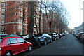
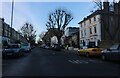
4
Randolph Avenue, Maida Vale
This is around the northern beginning of these type of houses which stretch from here to the other side of Kensington and much of the areas in between such as Paddington and Bayswater.
Image: © David Howard
Taken: 2 Jul 2008
0.05 miles
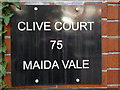
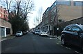
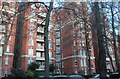
8

Flats by Lanark Road, Maida Vale
It's called Stuart Tower
Image: © David Howard
Taken: 20 Jan 2022
0.06 miles

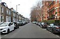
10
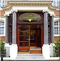
Maida Vale - Sandringham Court
Entrance to Sandringham Court, a period building.
Image: © Oxfordian Kissuth
Taken: Unknown
0.06 miles