IMAGES TAKEN NEAR TO
Stratford Road, LONDON, W8 6RA
Introduction
This page details the photographs taken nearby to Stratford Road, W8 6RA by members of the Geograph project.
The Geograph project started in 2005 with the aim of publishing, organising and preserving representative images for every square kilometre of Great Britain, Ireland and the Isle of Man.

There are currently over 7.5m images from over14,400 individuals and you can help contribute to the project by visiting https://www.geograph.org.uk
Image Map
Images are licensed for reuse under creativecommons.org/licenses/by-sa/2.0
Notes
- Clicking on the map will re-center to the selected point.
- The higher the marker number, the further away the image location is from the centre of the postcode.
Image Listing (255 Images Found)
Images are licensed for reuse under creativecommons.org/licenses/by-sa/2.0
Image
Details
Distance
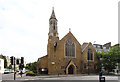
1
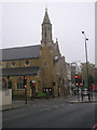
St Philip's Church, Junction of Stratford Road and Earl's Court Road, London W8
Image: © Robin Sones
Taken: 27 Nov 2007
0.03 miles
3
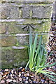
Benchmark on buttress of St Philip's Church
Ordnance Survey cut mark benchmark described on the Bench Mark Database at http://www.bench-marks.org.uk/bm47238
Image: © Roger Templeman
Taken: 14 Feb 2013
0.03 miles
5
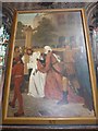
Inside St Cuthbert, Philbeach Gardens (3)
Image: © Basher Eyre
Taken: 2 Aug 2014
0.04 miles
7
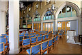
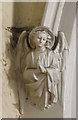
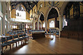
St Philip, Earl Court Road - South arcade
Image: © John Salmon
Taken: 17 Jun 2015
0.04 miles
9
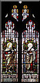
St Philip, Earl Court Road - Stained glass window
Image: © John Salmon
Taken: 17 Jun 2015
0.04 miles