IMAGES TAKEN NEAR TO
Abingdon Road, LONDON, W8 6AR
Introduction
This page details the photographs taken nearby to Abingdon Road, W8 6AR by members of the Geograph project.
The Geograph project started in 2005 with the aim of publishing, organising and preserving representative images for every square kilometre of Great Britain, Ireland and the Isle of Man.

There are currently over 7.5m images from over14,400 individuals and you can help contribute to the project by visiting https://www.geograph.org.uk
Image Map
Images are licensed for reuse under creativecommons.org/licenses/by-sa/2.0
Notes
- Clicking on the map will re-center to the selected point.
- The higher the marker number, the further away the image location is from the centre of the postcode.
Image Listing (306 Images Found)
Images are licensed for reuse under creativecommons.org/licenses/by-sa/2.0
Image
Details
Distance
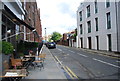
1
House at junction of Allen Street and Abingdon Villas
Image: © Andrew Wilson
Taken: 9 Dec 2012
0.01 miles
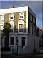
2
The Kensington Arms (closed)
Closed and shuttered, but in good condition with a 'Sold' sign.
Image: © Robin Webster
Taken: 13 May 2012
0.03 miles
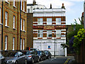
3
The Abingdon Public House, Abingdon Road, London W8
At Junction with Abingdon Villas W8
Image: © Robin Sones
Taken: 23 Jan 2008
0.03 miles
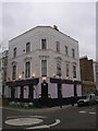
4
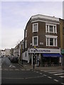
Pizza Express at Junction of Earl's Court Road and Cope Place, London W8
Image: © Robin Sones
Taken: 30 Nov 2007
0.04 miles

9
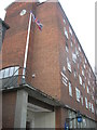
Kensington Police Station, Earl's Court Road, London W8
Image: © Robin Sones
Taken: 30 Nov 2007
0.05 miles