IMAGES TAKEN NEAR TO
Chantry Square, LONDON, W8 5UL
Introduction
This page details the photographs taken nearby to Chantry Square, W8 5UL by members of the Geograph project.
The Geograph project started in 2005 with the aim of publishing, organising and preserving representative images for every square kilometre of Great Britain, Ireland and the Isle of Man.

There are currently over 7.5m images from over14,400 individuals and you can help contribute to the project by visiting https://www.geograph.org.uk
Image Map
Images are licensed for reuse under creativecommons.org/licenses/by-sa/2.0
Notes
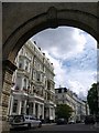
- Clicking on the map will re-center to the selected point.
- The higher the marker number, the further away the image location is from the centre of the postcode.
Image Listing (269 Images Found)
Images are licensed for reuse under creativecommons.org/licenses/by-sa/2.0
Image
Details
Distance
1
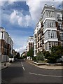
St Mary's Place, Kensington
Smart apartments on the south side of Kensington.
Image: © Derek Harper
Taken: 31 Jul 2009
0.02 miles
2
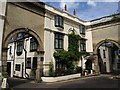
Archways, Cornwall Gardens
Image: © Derek Harper
Taken: 31 Jul 2009
0.05 miles
5
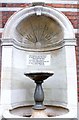
Fountain in Marloes Road, W8
The fountain is built into the wall of the gatehouse of the old St. Mary Abbots Hospital, very little remains of the old site apart from part of an old workhouse inside and out of public view, the perimeter railings/fence and the gatehouse.
See: Image], Image]
Image: © Phillip Perry
Taken: 10 Aug 2010
0.06 miles
6
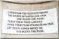
Fountain in Marloes Road II, W8
Image: © Phillip Perry
Taken: 10 Aug 2010
0.06 miles
7
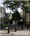
View along Lexham Gardens Walk from Lexham Gardens
Looking north-northeast.
Image: © Robert Lamb
Taken: 14 Jun 2014
0.06 miles
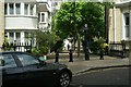
8
Kensington Green, W8
This is the site of the former St. Mary Abbots Hospital in Marloes Road,
it had various name changes during its history -
see: http://www.ezitis.myzen.co.uk/stmaryabbots.html
As a maternity unit it closed in 1971, and the hospital itself closed eventually in 1992.
The site is now part of a gated community called Kensington Green.
See: Image], Image]
Image: © Phillip Perry
Taken: 10 Aug 2010
0.07 miles
9
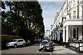
Cornwall Gardens
The reverse view looking out through the archway shown on the left of Image, with terraces on the north side of Cornwall Gardens on either side of the junction (closed to vehicles) with Stanford Road. The Metropolitan and District railways runs directly underneath this junction, and its construction in the 1860s disrupted the building of the estates.
Image: © Derek Harper
Taken: 31 Jul 2009
0.07 miles
10
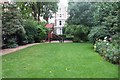
Lexham Gardens garden, W8
One of the many private gated gardens in the Kensington/Earls Court area
Image: © Phillip Perry
Taken: 10 Aug 2010
0.07 miles