IMAGES TAKEN NEAR TO
Wrights Lane, LONDON, W8 5SH
Introduction
This page details the photographs taken nearby to Wrights Lane, W8 5SH by members of the Geograph project.
The Geograph project started in 2005 with the aim of publishing, organising and preserving representative images for every square kilometre of Great Britain, Ireland and the Isle of Man.

There are currently over 7.5m images from over14,400 individuals and you can help contribute to the project by visiting https://www.geograph.org.uk
Image Map
Images are licensed for reuse under creativecommons.org/licenses/by-sa/2.0
Notes
- Clicking on the map will re-center to the selected point.
- The higher the marker number, the further away the image location is from the centre of the postcode.
Image Listing (598 Images Found)
Images are licensed for reuse under creativecommons.org/licenses/by-sa/2.0
Image
Details
Distance
2
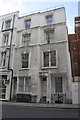
#10 Wright's Lane
There is an OS benchmark Image on the front right corner of the house, next to the screen in front of the Seventh Church of Christ Scientist London. On the left of the house is the 'Muffin Man' shop. The house has a basement as well as the 4 storeys above ground.
Image: © Roger Templeman
Taken: 14 Feb 2013
0.01 miles
3
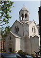
St Sarkis Armenian Church, Iverna Gardens
The church was open because the adjacent square participated in the Open Garden Squares Weekend. It was built in 1922-3, paid for by Calouste Gulbenkian; for a detailed description of the architecture see British History Online http://www.british-history.ac.uk/report.asp?compid=50334#s4. For information about the Armenian Apostolic Church see http://www.accc.org.uk/%20%20The%20Church/%20%20the%20church.htm on the website http://www.accc.org.uk/default.htm of the Armenian Community Council.
Image: © David Hawgood
Taken: 10 Jun 2007
0.02 miles
4
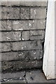
Benchmark on #10 Wright's Lane
Ordnance Survey cut mark benchmark described on the Bench Mark Database at http://www.bench-marks.org.uk/bm47266
Image: © Roger Templeman
Taken: 14 Feb 2013
0.02 miles
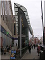
6
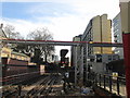
Line south of High Street Kensington station
A large hotel right next to the line
Image: © John Slater
Taken: 10 Mar 2015
0.03 miles
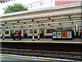
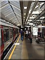
8
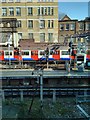
London Underground Train leaving High Street Kensington Station
Image: © PAUL FARMER
Taken: 5 Mar 2013
0.03 miles
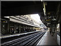
9
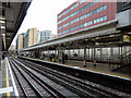
High Street Kensington underground station
The above ground, underground station at High Street Kensington on the District / Circle lines.
Image: © David P Howard
Taken: 16 Nov 2015
0.04 miles