IMAGES TAKEN NEAR TO
Stanford Road, LONDON, W8 5QL
Introduction
This page details the photographs taken nearby to Stanford Road, W8 5QL by members of the Geograph project.
The Geograph project started in 2005 with the aim of publishing, organising and preserving representative images for every square kilometre of Great Britain, Ireland and the Isle of Man.

There are currently over 7.5m images from over14,400 individuals and you can help contribute to the project by visiting https://www.geograph.org.uk
Image Map
Images are licensed for reuse under creativecommons.org/licenses/by-sa/2.0
Notes
- Clicking on the map will re-center to the selected point.
- The higher the marker number, the further away the image location is from the centre of the postcode.
Image Listing (273 Images Found)
Images are licensed for reuse under creativecommons.org/licenses/by-sa/2.0
Image
Details
Distance
1
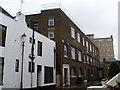
Kensington Gardens Telephone Exchange
Situated in South End Row W8 5BS, this TE has the code WRKGDN and used to have WEStern numbers until the late 1960s. It now provides telephone and broadband services to 6,073 residential and 575 non-residential premises in the Kensington Gardens area using 0207-937, 938 xxxx numbers and some other numbers allocated to Inner London.
Image: © David Hillas
Taken: 6 Jan 2011
0.02 miles
2
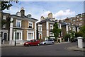
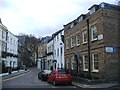
Stanford Villas, Kensington
Four smart villas divided into semis, and dating from 1851-2. "George Smith Stredder built fifteen houses, which were a mixture of detached and semi-detached, known as Stanford Villas." http://www.barrettssolicitors.co.uk/Kensington/streets/stanford_road.htm . "They have stock-brick fronts neatly outlined with continuous bands of diamond relief quoins and deep bands of frieze, now lacking eaves brackets and ground-floor window entablatures for all but Nos. 32–34. The arched-headed doors with pilastered cases are set well back from the road".
From: 'Kensington New Town', Survey of London: volume 42: Kensington Square to Earl's Court (1986), pp. 130-150. URL: http://www.british-history.ac.uk/report.aspx?compid=50314 Date accessed: 18 August 2009. A diagram of numbers 32-34, the villa behind the red car, also appears here.
Image: © Derek Harper
Taken: 31 Jul 2009
0.05 miles
4
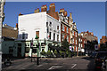
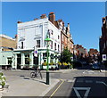
The Builders Arms
Located on the corner of Stanford Road and St.Albans Grove.
Image: © Martin Addison
Taken: 27 Jan 2012
0.05 miles
5
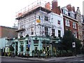
The Builders Arms, Kensington Court Place, London
Image: © PAUL FARMER
Taken: 24 Jul 2012
0.05 miles
7
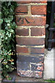
Benchmark on wall of Hamston House, Kensington Court Place
Ordnance Survey cut mark benchmark described on the Bench Mark Database at http://www.bench-marks.org.uk/bm47272
Image: © Roger Templeman
Taken: 14 Feb 2013
0.06 miles
8
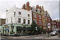
Builders Arms and Hamston House, Kensington Court Place
There is an OS benchmark Image on the end of the wall between the two buildings
Image: © Roger Templeman
Taken: 14 Feb 2013
0.06 miles
10
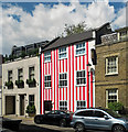
Stripe tease, South End
The owner went for this interesting look apparently to get back at neighbours who had objected to her application to demolish the building and replace with a new house including a two-storey basement. Since it stands in a conservation area, Kensington and Chelsea Council has since demanded she return it to its original state.
The trend of excavating basements (creating so-called "iceberg homes") among London's super-rich has reached such a scale in K&C that the council has recently limited them to a single storey and banned them altogether from listed buildings.
Image: © Stephen Richards
Taken: 30 Apr 2015
0.07 miles