IMAGES TAKEN NEAR TO
Derry Street, LONDON, W8 5HF
Introduction
This page details the photographs taken nearby to Derry Street, W8 5HF by members of the Geograph project.
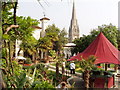
The Geograph project started in 2005 with the aim of publishing, organising and preserving representative images for every square kilometre of Great Britain, Ireland and the Isle of Man.

There are currently over 7.5m images from over14,400 individuals and you can help contribute to the project by visiting https://www.geograph.org.uk
Image Map
Images are licensed for reuse under creativecommons.org/licenses/by-sa/2.0
Notes
- Clicking on the map will re-center to the selected point.
- The higher the marker number, the further away the image location is from the centre of the postcode.
Image Listing (600 Images Found)
Images are licensed for reuse under creativecommons.org/licenses/by-sa/2.0
Image
Details
Distance
1
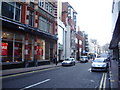
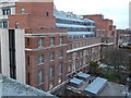
London : Kensington - Derry Street
Derry Street and Northcliffe House which is home to the Daily Mail.
Image: © Lewis Clarke
Taken: 9 Aug 2011
0.01 miles
2
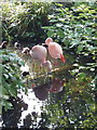
Flamingos in the Roof Gardens, Kensington
The English Woodland garden has a stream and pools and fish, ducks and flamingos. See Image for more details.
Image: © David Hawgood
Taken: 10 Jun 2007
0.02 miles
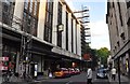
3
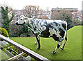
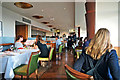
Rooftop grazing
Babylon Restaurant, Kensington
Image: © Anthony O'Neil
Taken: 22 Dec 2016
0.02 miles
4
The Roof Gardens, Kensington High Street
This is the Spanish Garden (see also Image), part of the one and a half acre garden http://www.roofgardens.com/the_gardens/map/ above the sixth floor of the former Derry and Toms Department store. View to the spire of St Mary Abbotts. Visited when it participated in Open Garden Squares Weekend, but it is available for public visits when there is no private function.
Image: © David Hawgood
Taken: 10 Jun 2007
0.02 miles
5
Rear view of Barkers'
The former Art Deco department store in Kensington.
Image: © Anthony O'Neil
Taken: 25 Nov 2013
0.02 miles
6
Babylon Roof Gardens Restaurant
Kensington High Street
Image: © Anthony O'Neil
Taken: 22 Dec 2016
0.02 miles
7
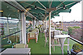
Babylon Restaurant Terrace
Kensington High Street
Image: © Anthony O'Neil
Taken: 22 Dec 2016
0.02 miles
8
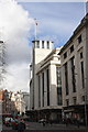
Barkers, Kensington High Street
The flagstaff on top of the Barkers building is an Ordnance Survey intersected station trig point, http://www.trigpointinguk.com/trigs/trig-details.php?t=11186
Image: © Roger Templeman
Taken: 14 Feb 2013
0.02 miles
9

Roof-line, Barkers of Kensington
Former department store, built to a design by architect Bernard George in 1933.
Image: © Jim Osley
Taken: 16 Feb 2018
0.02 miles