IMAGES TAKEN NEAR TO
Palace Green, LONDON, W8 4QB
Introduction
This page details the photographs taken nearby to Palace Green, W8 4QB by members of the Geograph project.
The Geograph project started in 2005 with the aim of publishing, organising and preserving representative images for every square kilometre of Great Britain, Ireland and the Isle of Man.

There are currently over 7.5m images from over14,400 individuals and you can help contribute to the project by visiting https://www.geograph.org.uk
Image Map
Images are licensed for reuse under creativecommons.org/licenses/by-sa/2.0
Notes
- Clicking on the map will re-center to the selected point.
- The higher the marker number, the further away the image location is from the centre of the postcode.
Image Listing (670 Images Found)
Images are licensed for reuse under creativecommons.org/licenses/by-sa/2.0
Image
Details
Distance
1

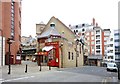
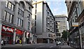
Cafe Rouge, Old Court Yard, London W8
On the left can be seen the entrance to the shopping area of Lancer Square.
Image: © Robin Sones
Taken: 12 Feb 2008
0.03 miles
2
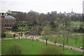
Kensington Palace & Gardens
A view of the Palace and the gardens and to the right the park as seen from one of the rooms of Kensington Gardens Hotel. Out of shot to the right is The Royal Albert Hall & the monument to King Albert. In the distance the city of London and above the hotel, one of the flight paths for aircraft landing at nearby Heathrow airport which is behind the photographer.
Image: © Alan Pennington
Taken: 14 Apr 2006
0.03 miles
3
Kensington High Street/Kensington Road, W8
Kensington High Street where it meets Kensington Road. The Royal Garden Hotel is on the left.
Image: © Phillip Perry
Taken: 10 Jun 2008
0.04 miles
4

Orange Way after Wiltshire (641)
The walk goes east along this passage from Kensington Church Street.
Image: © Shazz
Taken: 23 Sep 2013
0.05 miles


8
National Westminster Bank, Kensington High Street, London W8
At the junction with Young Street
Image: © Robin Sones
Taken: 12 Feb 2008
0.06 miles
9
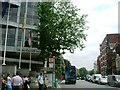
London : Kensington - Kensington High Street
Kensington High Street is the main shopping street in Kensington, west London. The area is identified in the London Plan as one of 35 major centres in Greater London.
Image: © Lewis Clarke
Taken: 9 Aug 2011
0.06 miles
10
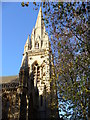
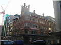
St Mary Abbots Church, Kensington
The parish church sits at the corner of Kensington High and Church streets. It was rebuilt by Sir George Gilbert Scott in 1869-72 and has a 254 feet high spire, reputedly London's highest spire, modelled on St Mary Redcliffe in Bristol. Its name comes from the 1100 grant of land in Kensington to abbots in Abingdon.
Image: © Colin Smith
Taken: 29 Nov 2006
0.06 miles