IMAGES TAKEN NEAR TO
Wilmot Place, LONDON, W7 3TY
Introduction
This page details the photographs taken nearby to Wilmot Place, W7 3TY by members of the Geograph project.
The Geograph project started in 2005 with the aim of publishing, organising and preserving representative images for every square kilometre of Great Britain, Ireland and the Isle of Man.

There are currently over 7.5m images from over14,400 individuals and you can help contribute to the project by visiting https://www.geograph.org.uk
Image Map
Images are licensed for reuse under creativecommons.org/licenses/by-sa/2.0
Notes
- Clicking on the map will re-center to the selected point.
- The higher the marker number, the further away the image location is from the centre of the postcode.
Image Listing (102 Images Found)
Images are licensed for reuse under creativecommons.org/licenses/by-sa/2.0
Image
Details
Distance
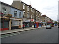
1
Boston Road, Hanwell
The A4001 (becomes the A3002) which connects Hanwell with Boston Manor and Brentford.
Image: © Martin Addison
Taken: 6 Apr 2012
0.03 miles
3
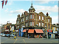
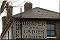
Corner shops, Hanwell
The corner greengrocer's shop looks as if it was something else once. On the 1870s map, but not later maps, a police station (T division) is shown hereabouts, probably this site, but is the building old enough?
Image: © Robin Webster
Taken: 6 Oct 2012
0.07 miles
4
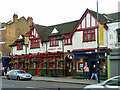
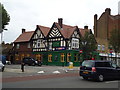
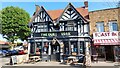
The Kings Arms, Hanwell
Convenient for the drinking punter.
Image: © Robin Webster
Taken: 6 Oct 2012
0.07 miles
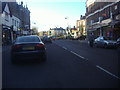
7
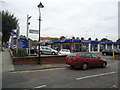
Robins and Day car dealership, Hanwell
Image: © Stacey Harris
Taken: 30 Aug 2011
0.08 miles