IMAGES TAKEN NEAR TO
Shirley Gardens, LONDON, W7 3PU
Introduction
This page details the photographs taken nearby to Shirley Gardens, W7 3PU by members of the Geograph project.
The Geograph project started in 2005 with the aim of publishing, organising and preserving representative images for every square kilometre of Great Britain, Ireland and the Isle of Man.

There are currently over 7.5m images from over14,400 individuals and you can help contribute to the project by visiting https://www.geograph.org.uk
Image Map
Images are licensed for reuse under creativecommons.org/licenses/by-sa/2.0
Notes
- Clicking on the map will re-center to the selected point.
- The higher the marker number, the further away the image location is from the centre of the postcode.
Image Listing (73 Images Found)
Images are licensed for reuse under creativecommons.org/licenses/by-sa/2.0
Image
Details
Distance

2
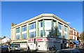
Deco on the Corner
At the junction of Broadway with Eccleston Road.
The map marks this as "Govt Offs" but judging by the To Let sign that's no longer the case.
Image: © Des Blenkinsopp
Taken: 27 Oct 2014
0.08 miles
3
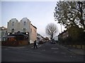
Grosvenor Avenue at the junction of Uxbridge Road
Image: © David Howard
Taken: 28 Nov 2014
0.09 miles
4
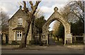
Kensington Cemetery arched entrance and lodge
Built c.1855 to the designs of architect Thomas Allom.
Image: © Jim Osley
Taken: 6 Feb 2015
0.10 miles
5
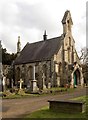
Kensington Cemetery chapel
Built c.1855 to the designs of architect Thomas Allom. Disused.
Image: © Jim Osley
Taken: 6 Feb 2015
0.10 miles
6

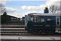
Great Western mainline, West Ealing/Hanwell borders
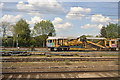
Looking west along the Great Western mainline. A Heathrow Express train heads to the airport. The industrial buildings on the left are the workshops of Plasser Machinery, Parts & Services Ltd, who maintain the Plasser and Theurer rail track maintenance machines.
Image: © Peter Jordan
Taken: 18 Mar 2006
0.13 miles
7
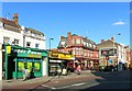
Pub, Pawn and Paddy Power
A parade of premises on the north side of Ealing Broadway.
Image: © Des Blenkinsopp
Taken: 27 Oct 2014
0.14 miles
8
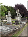
Hanwell cemetery
This cemetery is owned and managed by the Royal Borough of Kensington and Chelsea. It was founded in 1855 when inner London burial grounds were full and several large cemeteries were established in outer London or even further away.
Image: © David Hawgood
Taken: 10 Jun 2005
0.15 miles