IMAGES TAKEN NEAR TO
Walker Close, LONDON, W7 3NB
Introduction
This page details the photographs taken nearby to Walker Close, W7 3NB by members of the Geograph project.
The Geograph project started in 2005 with the aim of publishing, organising and preserving representative images for every square kilometre of Great Britain, Ireland and the Isle of Man.

There are currently over 7.5m images from over14,400 individuals and you can help contribute to the project by visiting https://www.geograph.org.uk
Image Map
Images are licensed for reuse under creativecommons.org/licenses/by-sa/2.0
Notes
- Clicking on the map will re-center to the selected point.
- The higher the marker number, the further away the image location is from the centre of the postcode.
Image Listing (259 Images Found)
Images are licensed for reuse under creativecommons.org/licenses/by-sa/2.0
Image
Details
Distance
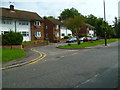
3
Looking along Lower Boston Road from Marlow Court
Image: © Shazz
Taken: 12 Sep 2013
0.06 miles
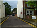
8
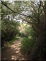
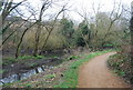
Fitzherbert Walk
The path leads south through woodland from the Uxbridge Road west of Hanwell Bridge, with the River Brent just off to the left. "This footpath is called Fitzherbert Walk after Luke Fitzherbert, who campaigned during the 1970s for the creation of the Brent River Park" http://www.walklondon.org.uk/uploads/File/sections/CR8_Directions.pdf .
Image: © Derek Harper
Taken: 20 Sep 2010
0.06 miles
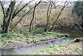
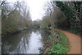
9

Brent River Walk and Ealing Hospital
The path is also the Capital Ring.
Image: © David Hawgood
Taken: 12 Jan 2016
0.06 miles