IMAGES TAKEN NEAR TO
Conolly Road, LONDON, W7 3JW
Introduction
This page details the photographs taken nearby to Conolly Road, W7 3JW by members of the Geograph project.
The Geograph project started in 2005 with the aim of publishing, organising and preserving representative images for every square kilometre of Great Britain, Ireland and the Isle of Man.

There are currently over 7.5m images from over14,400 individuals and you can help contribute to the project by visiting https://www.geograph.org.uk
Image Map
Images are licensed for reuse under creativecommons.org/licenses/by-sa/2.0
Notes
- Clicking on the map will re-center to the selected point.
- The higher the marker number, the further away the image location is from the centre of the postcode.
Image Listing (252 Images Found)
Images are licensed for reuse under creativecommons.org/licenses/by-sa/2.0
Image
Details
Distance
1
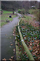
Conolly Dell
This small rest garden was purchased by the former Hanwell Urban District Council for £1,115 and opened in 1912.
Image: © Stephen McKay
Taken: 15 Jan 2011
0.03 miles
2
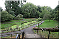
Conolly Dell
Named after Sir John Conolly who was the resident physician at the Middlesex County Asylum and who introduced the principle of non-restraint into the treatment of the insane. The dell has recently been subject to restoration and improvement by Ealing Council.
Image: © Martin Addison
Taken: 4 Oct 2013
0.04 miles
3
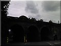
View of the Wharncliffe Viaduct from Golden Manor
The Wharncliffe Viaduct was designed by Isambard Kingdom Brunel in 1837 and was used to carry trains from London to Bristol, which it still does today, albeit the trains now serve a much wider variety of destinations e.g. Swansea, Taunton, Weston-super-Mare, etc. Looking south-southwest.
Image: © Robert Lamb
Taken: 5 Jun 2012
0.06 miles
5
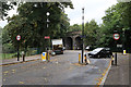
Decisions, Decisions
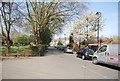
An interesting combination of speed control elements at the end of station Road in Hanwell. Drivers can choose to squeeze through the 7 foot gap or they can go over the speed hump in the middle. It is interesting to note that the gap on the right also shows the width rather than a more appropriate no entry sign.
Beyond the junction with York Avenue (on the right) the road becomes Golden Manor and passes under the Great Western mainline at the eastern end of Wharncliffe Viaduct.
Image: © Martin Addison
Taken: 4 Oct 2013
0.06 miles
6
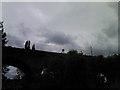
View of the Great Western Railway crossing the Wharncliffe Viaduct
Looking south-southwest from Golden Manor.
Image: © Robert Lamb
Taken: 5 Jun 2012
0.06 miles
7
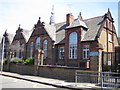
Hanwell: St Ann's School
In Springfield Road, this is now a day secondary special school for young people with severe learning difficulties.
Image: © Nigel Cox
Taken: 16 Jul 2006
0.07 miles
8
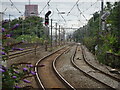
Hanwell 1st railway station, Greater London
Opened in 1838 by the Great Western Railway on its line from London Paddington to Reading, this station closed in 1877 when it was replaced by the current station some 250m east.
View west from the second station towards Southall and Reading. At the time the first station existed, there were only two broad gauge tracks here, to the left of the image. The two parallel platforms were located about where the "90" (miles per hour) sign is, at the point where Wharncliffe viaduct crosses Station Road. The station has moved, the road name hasn't!
Image: © Nigel Thompson
Taken: 20 Aug 2021
0.07 miles
10
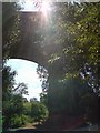
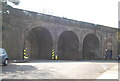
Wharnecliffe Viaduct (1837)
Built by Isambard Kingdom Brunel who was barely 30 when construction started in 1836 and was his first major structure designed by him. On the Great Western Line out of Paddington.
Image: © Phillip Perry
Taken: 26 Aug 2007
0.10 miles