IMAGES TAKEN NEAR TO
Manor Court Road, LONDON, W7 3EL
Introduction
This page details the photographs taken nearby to Manor Court Road, W7 3EL by members of the Geograph project.
The Geograph project started in 2005 with the aim of publishing, organising and preserving representative images for every square kilometre of Great Britain, Ireland and the Isle of Man.

There are currently over 7.5m images from over14,400 individuals and you can help contribute to the project by visiting https://www.geograph.org.uk
Image Map
Images are licensed for reuse under creativecommons.org/licenses/by-sa/2.0
Notes
- Clicking on the map will re-center to the selected point.
- The higher the marker number, the further away the image location is from the centre of the postcode.
Image Listing (196 Images Found)
Images are licensed for reuse under creativecommons.org/licenses/by-sa/2.0
Image
Details
Distance
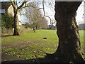
1
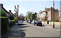
Alwyne Road Park
This tiny park is more like a town square and is almost continuous with Churchfields Recreation Ground. The houses beyond are in Alwyne Road.
Image: © Marathon
Taken: 7 Aug 2014
0.10 miles
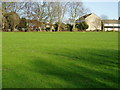
2
In Alwyne Road Park
This tiny park is more like a town square and is almost continuous with Churchfields Recreation Ground. The houses beyond are in Alwyne Road.
Image: © Marathon
Taken: 7 Aug 2014
0.10 miles
3
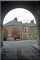
Golden Manor, Hanwell
Seen from under Golden Manor Viaduct which carries the Great Western Main Line.
Image: © Stephen McKay
Taken: 15 Jan 2011
0.10 miles
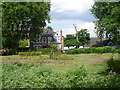
7
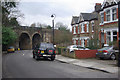
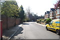
Golden Manor, Hanwell
This unusually named suburban street leads under the Great Western Main Line. The name has no historical connection.
Image: © Stephen McKay
Taken: 15 Jan 2011
0.11 miles
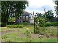
8

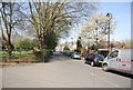
Manor Court Green / Alwyne Road Park
Officially called Manor Court Green, this small open space next to Churchfields Recreation Ground is also known as Alwyne Road Park. It is open to the public and maintained by local residents.
Image: © Mark Percy
Taken: 25 Apr 2023
0.12 miles