IMAGES TAKEN NEAR TO
Halford Place, LONDON, W7 3BU
Introduction
This page details the photographs taken nearby to Halford Place, W7 3BU by members of the Geograph project.
The Geograph project started in 2005 with the aim of publishing, organising and preserving representative images for every square kilometre of Great Britain, Ireland and the Isle of Man.

There are currently over 7.5m images from over14,400 individuals and you can help contribute to the project by visiting https://www.geograph.org.uk
Image Map
Images are licensed for reuse under creativecommons.org/licenses/by-sa/2.0
Notes
- Clicking on the map will re-center to the selected point.
- The higher the marker number, the further away the image location is from the centre of the postcode.
Image Listing (82 Images Found)
Images are licensed for reuse under creativecommons.org/licenses/by-sa/2.0
Image
Details
Distance
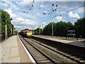
1
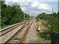
Looking up the line from Hanwell station
Hanwell station is on the original line of the Great Western Railway which opened on 4th June 1838, although Hanwell station opened on 1st December 1838. The station was renamed Hanwell and Elthorne on 1st April 1896, and reverted to Hanwell on 6th May 1974. The station was re-built in the 1870s and is grade II listed. On platform 2 is a station nameboard still bearing the pre-1974 name Hanwell and Elthorne - see http://www.geograph.org.uk/photo/4109136
In this view from the end of Platform 2, the two fast lines are to the right while the two slow lines are to the left. The line curving away to the left leads to the Drayton Green branch line although passenger trains do not use this spur.
Image: © Marathon
Taken: 7 Aug 2014
0.09 miles
3
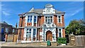
Hanwell Community Library
Hanwell Community Library is part of the Carnegie legacy in the London Borough of Ealing. It has been serving Hanwell since 1905.
In 2019 Ealing Council passed the responsibility for the day to day running of this and several other neighbourhood libraries to the community. This branch is run by Ealing Law Centre which occupies the same building.
Image: © Mark Percy
Taken: 14 Jul 2022
0.09 miles
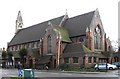
4
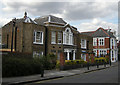
Cherington House
Built as a family home in the 1830s, this house was used as Council offices from 1892, and as a Health Centre from 1927. To the right can be seen the Hanwell Library which functioned as Hanwell Urban District Council offices from 1905 to 1926.
Image: © Tim Stuart
Taken: 15 Aug 2008
0.10 miles
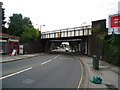
5
Hanwell station
Hanwell station is on the original line of the Great Western Railway which opened on 4th June 1838, although Hanwell station opened on 1st December 1838. The station was renamed Hanwell and Elthorne on 1st April 1896, and reverted to Hanwell on 6th May 1974. The station was re-built in the 1870s and is grade II listed. As can be seen here, on platform 2 is a station nameboard still bearing the pre-1974 name Hanwell and Elthorne.
This view is from the Paddington-bound platform 3. A freight train is heading through the station on the down slow line.
Image: © Marathon
Taken: 7 Aug 2014
0.10 miles
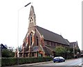
8
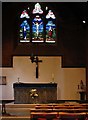
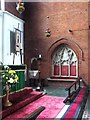
St Mellitus, Church Road, London W7 - Lady chapel
Image: © John Salmon
Taken: 6 Oct 2004
0.11 miles
9
St Mellitus, Church Road, London W7 - Piscina & sedilia
Image: © John Salmon
Taken: 6 Oct 2004
0.11 miles
10
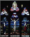
St Mellitus, Church Road, London W7 - Window
Image: © John Salmon
Taken: 6 Oct 2004
0.11 miles