IMAGES TAKEN NEAR TO
Lower Boston Road, LONDON, W7 2NR
Introduction
This page details the photographs taken nearby to Lower Boston Road, W7 2NR by members of the Geograph project.
The Geograph project started in 2005 with the aim of publishing, organising and preserving representative images for every square kilometre of Great Britain, Ireland and the Isle of Man.

There are currently over 7.5m images from over14,400 individuals and you can help contribute to the project by visiting https://www.geograph.org.uk
Image Map
Images are licensed for reuse under creativecommons.org/licenses/by-sa/2.0
Notes
- Clicking on the map will re-center to the selected point.
- The higher the marker number, the further away the image location is from the centre of the postcode.
Image Listing (178 Images Found)
Images are licensed for reuse under creativecommons.org/licenses/by-sa/2.0
Image
Details
Distance
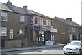
1
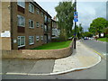
Looking along Lower Boston Road from Marlow Court
Image: © Shazz
Taken: 12 Sep 2013
0.01 miles
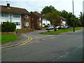
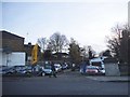
4
Looking east on the A4020 from the bridge over the River Brent
Image: © Shazz
Taken: 12 Sep 2013
0.04 miles
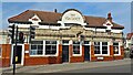
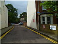
5
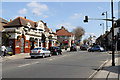
The Viaduct
A classic Fuller's public house with its glazed tile exterior. This pub is located at the western end of Hanwell on the A4020 Uxbridge Road, opposite the junction with Lower Boston Road.
Image: © Martin Addison
Taken: 6 Apr 2012
0.05 miles
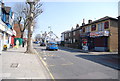
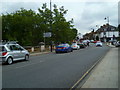
6
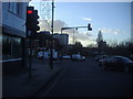
Lights on Hanwell Broadway at Lower Boston Road
Ealing hospital is on the left horizon
Image: © David Howard
Taken: 7 Dec 2011
0.05 miles