IMAGES TAKEN NEAR TO
Townholm Crescent, LONDON, W7 2LY
Introduction
This page details the photographs taken nearby to Townholm Crescent, W7 2LY by members of the Geograph project.
The Geograph project started in 2005 with the aim of publishing, organising and preserving representative images for every square kilometre of Great Britain, Ireland and the Isle of Man.

There are currently over 7.5m images from over14,400 individuals and you can help contribute to the project by visiting https://www.geograph.org.uk
Image Map
Images are licensed for reuse under creativecommons.org/licenses/by-sa/2.0
Notes
- Clicking on the map will re-center to the selected point.
- The higher the marker number, the further away the image location is from the centre of the postcode.
Image Listing (105 Images Found)
Images are licensed for reuse under creativecommons.org/licenses/by-sa/2.0
Image
Details
Distance
1
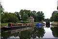
Hanwell Flight - The Southerly Lock Keeper's Cottage
Travelling from the Thames northwards this is the first of several lock keeper's cottages encountered when traversing the Hanwell Flight - 6 locks within 1/2 a mile, raising the water level by about 53ft.
Image: © Billy Abbott
Taken: 3 Jul 2005
0.11 miles
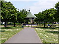
3
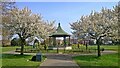
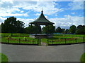
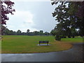
Elthorne Park bandstand
The name Elthorne goes back at least one thousand years. It was mentioned in the Domesday survey as being one of the six hundreds of the shire of Middlesex along with Edmonton, Gore, Hounslow, Ossulstone and Spelthorne.
The origin of the park goes back to the 1500s. The original much larger estate, called La Bromeland, was named after the wild yellow flowering Broom shrub, which still grows on the steep embankment of the river Brent.
In the 16th century Thomas Gresham's widow bought the freehold of 'Broomland', which later passed down through Osterley to the Earls of Jersey.
Fifteen years after the General Enclosure Act of 1801 the estate was reduced to 90 acres and then became known as Park Farm. At one time, with Cuckoo Farm it was one of the last two existing farms in Hanwell.
In 1908 Lord Jersey started negotiations with the Council and Middlesex County Council about the use of the land. During the negotiations he allowed a section of the land to be used as a temporary recreation ground.
The farmland was finally broken up around 1910. Some of the land is now open space and playing fields but seven and a half acres of the site were used to form Elthorne Park.
Lord Villiers and his mother, the Countess of Jersey, officially opened the park at 3pm on 11 June 1910. The opening, which had been postponed because of the death of King Edward VII on 6 May 1910, was said to be a grand affair, held in a large marquee with tea being served in the nearby mission church of St Thomas's.
Image: © Mark Percy
Taken: 28 Mar 2022
0.12 miles
7
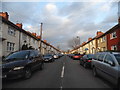
Boston Road at the corner of Humes Avenue
Image: © David Howard
Taken: 1 Feb 2014
0.12 miles
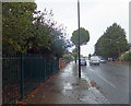
10

Snow in Studley Grange Road
Studley Grange Road after fairly heavy snow.
Image: © Matthew Purves
Taken: 2 Feb 2009
0.14 miles