IMAGES TAKEN NEAR TO
Cawdor Crescent, LONDON, W7 2DB
Introduction
This page details the photographs taken nearby to Cawdor Crescent, W7 2DB by members of the Geograph project.
The Geograph project started in 2005 with the aim of publishing, organising and preserving representative images for every square kilometre of Great Britain, Ireland and the Isle of Man.

There are currently over 7.5m images from over14,400 individuals and you can help contribute to the project by visiting https://www.geograph.org.uk
Image Map
Images are licensed for reuse under creativecommons.org/licenses/by-sa/2.0
Notes
- Clicking on the map will re-center to the selected point.
- The higher the marker number, the further away the image location is from the centre of the postcode.
Image Listing (121 Images Found)
Images are licensed for reuse under creativecommons.org/licenses/by-sa/2.0
Image
Details
Distance
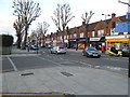
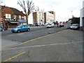
5
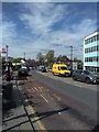
Shops on Boston Road
Near Boston Manor tube station. The yellow shop is a Post Office within a cafe.
Image: © Thomas Nugent
Taken: 29 Aug 2011
0.03 miles
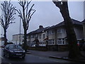
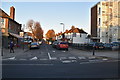
6
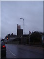
Boston Manor Tube station
From the north on Boston Road
Image: © David Howard
Taken: 13 Apr 2013
0.04 miles
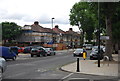
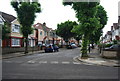
7
Boston Road, Boston Manor
This is the furthest south point of Hanwell before entering Brentford across the railway line.
Image: © David Howard
Taken: 1 Feb 2014
0.04 miles