IMAGES TAKEN NEAR TO
Saddleback Lane, LONDON, W7 2BA
Introduction
This page details the photographs taken nearby to Saddleback Lane, W7 2BA by members of the Geograph project.
The Geograph project started in 2005 with the aim of publishing, organising and preserving representative images for every square kilometre of Great Britain, Ireland and the Isle of Man.

There are currently over 7.5m images from over14,400 individuals and you can help contribute to the project by visiting https://www.geograph.org.uk
Image Map
Images are licensed for reuse under creativecommons.org/licenses/by-sa/2.0
Notes
- Clicking on the map will re-center to the selected point.
- The higher the marker number, the further away the image location is from the centre of the postcode.
Image Listing (133 Images Found)
Images are licensed for reuse under creativecommons.org/licenses/by-sa/2.0
Image
Details
Distance
1

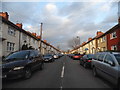
Snow in Studley Grange Road
Studley Grange Road after fairly heavy snow.
Image: © Matthew Purves
Taken: 2 Feb 2009
0.03 miles
2

Jessop Place, Hanwell
A new row of houses built along the side of St Margaret's Road
Image: © David Howard
Taken: 1 Feb 2014
0.03 miles
3

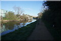
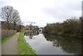
Grand Union Canal at Hanwell
The section of the Grand Union Canal through Hanwell Locks and Norwood from the River Thames at Brentford was opened in 1794. It was the first section of what was originally called the Grand Junction Canal. Its purpose was to provide a new, shorter and quicker transport route between London and Birmingham by connecting with a network of canals at Braunston near Daventry. When the canal reached Braunston in 1805 it cut 60 miles off the shortest alternative route.
In this view from the towpath beyond Hanwell Locks, the bridge carrying Trumpers Way is in the distance.
Image: © Marathon
Taken: 7 Aug 2014
0.04 miles
4

Piggeries Orchard
A pond has been dug to promote bio-diversity in this small open space off the north side of the Grand Union Canal towpath.
Image: © Mark Percy
Taken: 27 Mar 2022
0.04 miles
5
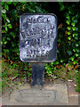
Mile Post by the River Brent
The cast iron marker reads as follows...
"G.J.C.Co.
Braunston
91
Miles"
See the plaque on the ground here Image
Image: © Thomas Nugent
Taken: 29 Aug 2011
0.04 miles
6
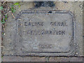
Plaque by the River Brent
On the ground beside mile post 91 Image The text reads as follows...
"Ealing Canal
Celebration
1993"
Image: © Thomas Nugent
Taken: 29 Aug 2011
0.04 miles
8
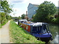
Grand Union Canal near Hanwell
The section of the Grand Union Canal through Hanwell Locks and Norwood from the River Thames at Brentford was opened in 1794. It was the first section of what was originally called the Grand Junction Canal. Its purpose was to provide a new, shorter and quicker transport route between London and Birmingham by connecting with a network of canals at Braunston near Daventry. When the canal reached Braunston in 1805 it cut 60 miles off the shortest alternative route.
In this view from the towpath beyond Hanwell Locks, the bridge carrying Trumpers Way is in the distance.
Image: © Marathon
Taken: 7 Aug 2014
0.05 miles