IMAGES TAKEN NEAR TO
Copley Close, LONDON, W7 1QW
Introduction
This page details the photographs taken nearby to Copley Close, W7 1QW by members of the Geograph project.
The Geograph project started in 2005 with the aim of publishing, organising and preserving representative images for every square kilometre of Great Britain, Ireland and the Isle of Man.

There are currently over 7.5m images from over14,400 individuals and you can help contribute to the project by visiting https://www.geograph.org.uk
Image Map
Images are licensed for reuse under creativecommons.org/licenses/by-sa/2.0
Notes
- Clicking on the map will re-center to the selected point.
- The higher the marker number, the further away the image location is from the centre of the postcode.
Image Listing (35 Images Found)
Images are licensed for reuse under creativecommons.org/licenses/by-sa/2.0
Image
Details
Distance
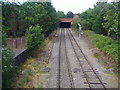
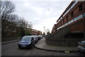
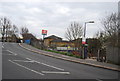
6
Drayton Green station, Ealing
Although Londoners are familiar with West Drayton few stop to think why it's called west if there's nowhere called Drayton. This is it, but although Drayton Green is the station name and many surrounding roads no one calls the area that now as it's become part of Ealing.
Image: © David Howard
Taken: 8 Jul 2008
0.10 miles
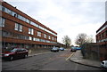
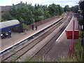
9
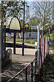
Drayton Green Station
Entrance to the up (London) platform.
Image: © Martin Addison
Taken: 13 Apr 2016
0.11 miles