IMAGES TAKEN NEAR TO
Shakespeare Road, LONDON, W7 1LS
Introduction
This page details the photographs taken nearby to Shakespeare Road, W7 1LS by members of the Geograph project.
The Geograph project started in 2005 with the aim of publishing, organising and preserving representative images for every square kilometre of Great Britain, Ireland and the Isle of Man.

There are currently over 7.5m images from over14,400 individuals and you can help contribute to the project by visiting https://www.geograph.org.uk
Image Map
Images are licensed for reuse under creativecommons.org/licenses/by-sa/2.0
Notes
- Clicking on the map will re-center to the selected point.
- The higher the marker number, the further away the image location is from the centre of the postcode.
Image Listing (49 Images Found)
Images are licensed for reuse under creativecommons.org/licenses/by-sa/2.0
Image
Details
Distance
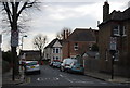
2
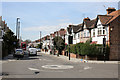
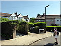
Drayton Bridge Road
Seen from the junction with Park Road.
Image: © Martin Addison
Taken: 13 Apr 2016
0.11 miles
4
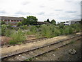
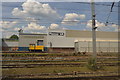
Disused railway sidings near Hanwell
Overgrown sidings in the "Ealing triangle".
Image: © Peter Whatley
Taken: 17 Jul 2010
0.11 miles
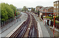
5
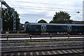
Lines divide south of Drayton Green Station
Image: © N Chadwick
Taken: 18 Mar 2012
0.12 miles
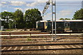
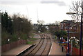
7
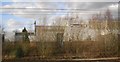
Drayton Green station, 1990
View southward, towards West Ealing (left), Hanwell (right): ex-GWR loop line, West Ealing/Hanwell - Greenford. The loop is traversed by a local service Ealing Broadway - Greenford, but is also a useful link between the Reading and North main lines for freight.
Image: © Ben Brooksbank
Taken: 16 Apr 1990
0.13 miles