IMAGES TAKEN NEAR TO
Ruislip Road East, LONDON, W7 1DA
Introduction
This page details the photographs taken nearby to Ruislip Road East, W7 1DA by members of the Geograph project.
The Geograph project started in 2005 with the aim of publishing, organising and preserving representative images for every square kilometre of Great Britain, Ireland and the Isle of Man.

There are currently over 7.5m images from over14,400 individuals and you can help contribute to the project by visiting https://www.geograph.org.uk
Image Map
Images are licensed for reuse under creativecommons.org/licenses/by-sa/2.0
Notes
- Clicking on the map will re-center to the selected point.
- The higher the marker number, the further away the image location is from the centre of the postcode.
Image Listing (27 Images Found)
Images are licensed for reuse under creativecommons.org/licenses/by-sa/2.0
Image
Details
Distance
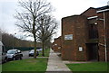
1
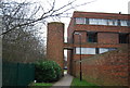
Corner House, Harp Road
Just to vary things a bit on these fairly similar streets, houses on the corner at junctions or cross roads are sometimes a slightly more elaborate design.
Image: © Des Blenkinsopp
Taken: 25 Jun 2013
0.08 miles
5
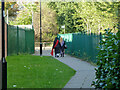
Path from Copley Close to Ruislip Road East, 2012
Redevelopment has changed things here, but there is still a way through.
Image: © Robin Webster
Taken: 13 Oct 2012
0.11 miles
7
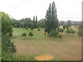
Bunker, Perivale Park
Part of the local golf course.
Image: © Peter Whatley
Taken: 17 Jul 2010
0.12 miles
9
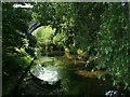
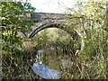
River Brent under the Railway
The Greenford branch crosses the Brent.
The River Brent rises in Barnet and joins the Thames at Brentford. It is 29km long. Upstream of this stretch it is often a fairly dull urban river but its course through Ealing is mostly in parkland. The Brent River Park Walk is a signed route between two sections of the Grand Union Canal Walk.
Image: © Des Blenkinsopp
Taken: 25 Jun 2013
0.14 miles