IMAGES TAKEN NEAR TO
Eyot Gardens, LONDON, W6 9TR
Introduction
This page details the photographs taken nearby to Eyot Gardens, W6 9TR by members of the Geograph project.
The Geograph project started in 2005 with the aim of publishing, organising and preserving representative images for every square kilometre of Great Britain, Ireland and the Isle of Man.

There are currently over 7.5m images from over14,400 individuals and you can help contribute to the project by visiting https://www.geograph.org.uk
Image Map
Images are licensed for reuse under creativecommons.org/licenses/by-sa/2.0
Notes
- Clicking on the map will re-center to the selected point.
- The higher the marker number, the further away the image location is from the centre of the postcode.
Image Listing (178 Images Found)
Images are licensed for reuse under creativecommons.org/licenses/by-sa/2.0
Image
Details
Distance
1
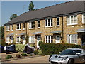
Terrace of houses in Chiswick
This is British Grove South.
Image: © David Hawgood
Taken: 24 May 2009
0.03 miles
2
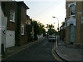
Chiswick Mall, W4
Chiswick Mall at the junction of Eyot Gardens.
Image: © Phillip Perry
Taken: 13 May 2008
0.05 miles
3
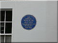
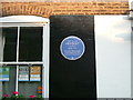
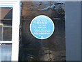
Blue plaque for Sir Emery Walker
The Typographer and antiquary, who lived here for three years in the 1930'
Image: © Eirian Evans
Taken: 15 Aug 2013
0.05 miles
4
Mulberry Walk, W6
7 cottages unless you knew they were there, you'd never find them.
Image: © Phillip Perry
Taken: 13 May 2008
0.05 miles
5
Hammersmith Terrace - Blue Plaque 3
Sir Alan Herbert? Me neither. The 3rd of 3 blue plaques in Hammersmith Terrace, W6.
Image: © Phillip Perry
Taken: 13 May 2008
0.06 miles
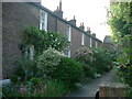
6
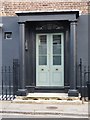
Doorway in Hammersmith Terrace - and a coal-hole
According to Pevsner, Hammersmith Terrace was built circa 1750, when the area was still rural - market gardening and orchards. The terrace has an odd plainness - the only architectural details to catch the eye are the doorways with their Tuscan columns, painted black in several cases.
The iron disc set in the pavement is a coal-hole cover. Many Georgian terraces were built so that their 'ground floor' was several feet above true ground level, leaving room for basements and coal cellars (see Sir John Summerson's book, 'Georgian London', chapter 5). In this case, at the front of the doorstep there is a row of little apertures - each the shape of a slice of melon - allowing light into the coal cellar.
Image: © Stefan Czapski
Taken: 1 Jun 2011
0.06 miles
7
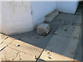
Boundary stone between Chiswick and Hammersmith
A nondescript stone, marking the boundary between the two boroughs. It is set in the pavement outside Cedar House on Chiswick Mall.
Image: © Eirian Evans
Taken: 20 Oct 2010
0.06 miles
8
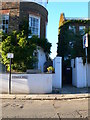
Cedar House, Chiswick Mall
Cedar House is at the boundary of Chiswick and Hammersmith and has the boundary stone by its gate to prove it Image
Image: © Eirian Evans
Taken: 20 Oct 2010
0.06 miles
9
Blue plaque, Hammersmith Terrace
To commemorate A.P.Herbert http://en.wikipedia.org/wiki/A._P._Herbert
Image: © Eirian Evans
Taken: 20 Oct 2010
0.07 miles
10
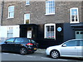
House with blue plaque, Hammersmith Terrace
The plaque Image commemorates A.P.Herbert, who loved this house by the Thames.
Image: © Eirian Evans
Taken: 20 Oct 2010
0.07 miles