IMAGES TAKEN NEAR TO
Rannoch Road, LONDON, W6 9SW
Introduction
This page details the photographs taken nearby to Rannoch Road, W6 9SW by members of the Geograph project.
The Geograph project started in 2005 with the aim of publishing, organising and preserving representative images for every square kilometre of Great Britain, Ireland and the Isle of Man.

There are currently over 7.5m images from over14,400 individuals and you can help contribute to the project by visiting https://www.geograph.org.uk
Image Map
Images are licensed for reuse under creativecommons.org/licenses/by-sa/2.0
Notes
- Clicking on the map will re-center to the selected point.
- The higher the marker number, the further away the image location is from the centre of the postcode.
Image Listing (151 Images Found)
Images are licensed for reuse under creativecommons.org/licenses/by-sa/2.0
Image
Details
Distance
1

Hammersmith - Terrace Housing
The corner of Parfrey Street and Manbre Road close to the River Thames.
The Fulham Reach major re-development is going on in the background. A brewery is being turned into 744 homes.
Image: © James Emmans
Taken: 2 Jun 2022
0.06 miles
2
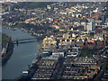
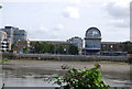
Hammersmith and Fulham from the air
Hammersmith Bridge can be seen crossing the Thames. The A4 Hammersmith Flyover can also be seen.
Image: © Thomas Nugent
Taken: 28 Feb 2019
0.06 miles
3
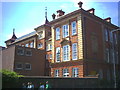
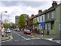
Melcombe School, Fulham Palace Road, Hammersmith.
Image: © Noel Foster
Taken: 16 Jul 2005
0.08 miles

6
Looking across the River Thames to Fulham / Hammersmith
Image: © N Chadwick
Taken: 25 Aug 2010
0.09 miles
9
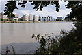
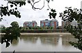
Housing at Fulham
Housing overlooking the River Thames at Fulham viewed from the Thames Path on the Surrey bank.
Image: © Philip Halling
Taken: 24 Sep 2011
0.10 miles
10
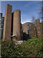
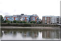
Thames Reach
A view of the blocks to the north of Image The architects were the Richard Rogers Partnership, whose offices are immediately to the south in Image "The use of brick, unusual in the practice’s mature work, reflects the attention paid to the context. By breaking the scheme into three blocks, views are provided through from the street to the river, where there is a generous public promenade" http://rsh-p.com/work/buildings/thames_reach_housing . This seems to be untrue, as the Thames Path runs along Rainville Road at the rear of the properties, and I was unable to view the river in between the blocks.
Image: © Derek Harper
Taken: 15 Apr 2010
0.10 miles