IMAGES TAKEN NEAR TO
King Street, LONDON, W6 9NJ
Introduction
This page details the photographs taken nearby to King Street, W6 9NJ by members of the Geograph project.
The Geograph project started in 2005 with the aim of publishing, organising and preserving representative images for every square kilometre of Great Britain, Ireland and the Isle of Man.

There are currently over 7.5m images from over14,400 individuals and you can help contribute to the project by visiting https://www.geograph.org.uk
Image Map
Images are licensed for reuse under creativecommons.org/licenses/by-sa/2.0
Notes
- Clicking on the map will re-center to the selected point.
- The higher the marker number, the further away the image location is from the centre of the postcode.
Image Listing (163 Images Found)
Images are licensed for reuse under creativecommons.org/licenses/by-sa/2.0
Image
Details
Distance
5
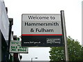
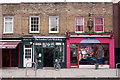
Welcome to Hammersmith & Fulham
The general bog-standard sign to greet visitors to the borough, King Street, Hammersmith, W6.
Image: © Phillip Perry
Taken: 19 Aug 2007
0.04 miles
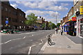
6
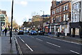
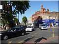
Chiswick High Road (A315)
Showing position of W6 16.
Image: © JThomas
Taken: 23 May 2022
0.04 miles
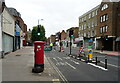
7
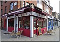
London : Hammersmith - King Street A315
Looking down King Street where there were no cars travelling on the road at this point in time.
Image: © Lewis Clarke
Taken: 13 May 2011
0.04 miles
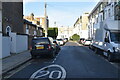
10
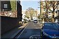
Goldhawk Road, junction with Chiswick High Road
Image: © Chris Gunns
Taken: 12 Sep 2009
0.06 miles