IMAGES TAKEN NEAR TO
Weltje Road, LONDON, W6 9LS
Introduction
This page details the photographs taken nearby to Weltje Road, W6 9LS by members of the Geograph project.
The Geograph project started in 2005 with the aim of publishing, organising and preserving representative images for every square kilometre of Great Britain, Ireland and the Isle of Man.

There are currently over 7.5m images from over14,400 individuals and you can help contribute to the project by visiting https://www.geograph.org.uk
Image Map
Images are licensed for reuse under creativecommons.org/licenses/by-sa/2.0
Notes
- Clicking on the map will re-center to the selected point.
- The higher the marker number, the further away the image location is from the centre of the postcode.
Image Listing (269 Images Found)
Images are licensed for reuse under creativecommons.org/licenses/by-sa/2.0
Image
Details
Distance
2
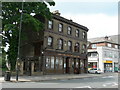
Ruby Grand, King Street, W6
This bar used to be the Hampshire Hog pub.
Image: © Danny P Robinson
Taken: 7 Jun 2008
0.02 miles
3
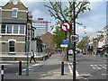
Pavement on King Street, W6
Near Rivercourt Road.
Image: © Danny P Robinson
Taken: 7 Jun 2008
0.02 miles
4
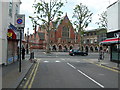
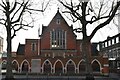
Latymer Upper School, Hammersmith
As seen looking across King Street from Ravenscourt Road.
Image: © Danny P Robinson
Taken: 7 Jun 2008
0.04 miles
5
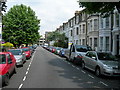
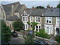
Weltje Road, W6
Looking towards King Street.
Image: © Danny P Robinson
Taken: 7 Jun 2008
0.04 miles
9
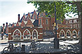
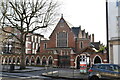
Latymer Upper School, Hammersmith
Founded in the 17th century
Image: © Anthony O'Neil
Taken: 22 May 2017
0.06 miles
10
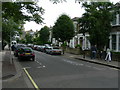
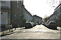
Rivercourt Road, W6
Taken near the corner of the Great West Road.
Image: © Danny P Robinson
Taken: 7 Jun 2008
0.06 miles