IMAGES TAKEN NEAR TO
Riverside Gardens, LONDON, W6 9LE
Introduction
This page details the photographs taken nearby to Riverside Gardens, W6 9LE by members of the Geograph project.
The Geograph project started in 2005 with the aim of publishing, organising and preserving representative images for every square kilometre of Great Britain, Ireland and the Isle of Man.

There are currently over 7.5m images from over14,400 individuals and you can help contribute to the project by visiting https://www.geograph.org.uk
Image Map
Images are licensed for reuse under creativecommons.org/licenses/by-sa/2.0
Notes
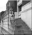
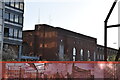
- Clicking on the map will re-center to the selected point.
- The higher the marker number, the further away the image location is from the centre of the postcode.
Image Listing (366 Images Found)
Images are licensed for reuse under creativecommons.org/licenses/by-sa/2.0
Image
Details
Distance
1
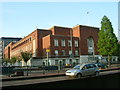
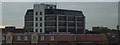
Hammersmith Town Hall in daylight
Hammersmith Town Hall this time taken on the left of the tree. The bigger building to the left and back of the 1930's version is the soon to be demolished modern main entrance.
Image: © Phillip Perry
Taken: 13 May 2008
0.02 miles
2
Father Thames at Hammersmith Town Hall
This is on the south side of Hammersmith Town Hall which was completed in 1939.
Listing and history on http://www.britishlistedbuildings.co.uk/en-201822-hammersmith-town-hall-non-civil-parish-g#.VhJ-6tn6nGg
Image: © Des Blenkinsopp
Taken: 30 Jul 2015
0.03 miles
3
Hammersmith Town Hall
Taken from the (A4) Great West Road, the rear of Hammersmith Town Hall, Hammersmith, London, W6.
Image: © Phillip Perry
Taken: 12 May 2008
0.03 miles
4
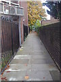
Path leading to A4 Ravenscourt Park
From Cromwell Avenue
Image: © David Howard
Taken: 31 Oct 2010
0.03 miles
5
Hammersmith Town Hall
Grade II listed. https://historicengland.org.uk/listing/the-list/list-entry/1079785
Image: © N Chadwick
Taken: 15 Dec 2019
0.04 miles
6
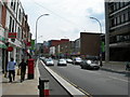
King Street, W6 (2)
Near Studland Street. Note the contraflow bike lane, allowing cyclists to take the most direct route to Hammersmith town centre -- vehicles have to go round a one way system.
Image: © Danny P Robinson
Taken: 7 Jun 2008
0.04 miles
7
Hammersmith Town Hall, W6
The modern extension at the front of the town hall.
Image: © Phillip Perry
Taken: 7 Oct 2010
0.06 miles
8
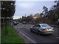
A4 eastbound, Ravenscourt Park
Heading towards Hammersmith and Kensington beyond
Image: © David Howard
Taken: 31 Oct 2010
0.06 miles
9
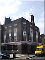
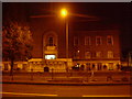
The Hope and Anchor Pub, Hammersmith
A Grade II listed building, former public house on the junction of MacBeth Street and Riverside Gardens (on the right).
Closed in October 2012 now converted into flats.
Image: © David Anstiss
Taken: 14 Apr 2013
0.06 miles
10
Hammersmith Town Hall
Hammersmith Town Hall seen from the Holiday Inn Express.
Image: © Peter McDermott
Taken: 7 Mar 2015
0.07 miles