IMAGES TAKEN NEAR TO
Queen Caroline Street, LONDON, W6 9EF
Introduction
This page details the photographs taken nearby to Queen Caroline Street, W6 9EF by members of the Geograph project.
The Geograph project started in 2005 with the aim of publishing, organising and preserving representative images for every square kilometre of Great Britain, Ireland and the Isle of Man.

There are currently over 7.5m images from over14,400 individuals and you can help contribute to the project by visiting https://www.geograph.org.uk
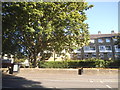
Image Map
Images are licensed for reuse under creativecommons.org/licenses/by-sa/2.0
Notes
- Clicking on the map will re-center to the selected point.
- The higher the marker number, the further away the image location is from the centre of the postcode.
Image Listing (443 Images Found)
Images are licensed for reuse under creativecommons.org/licenses/by-sa/2.0
Image
Details
Distance
2
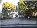
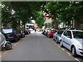
Worlidge Street from Hammersmith Bridge Road
You can see the two roads were once connected
Image: © David Howard
Taken: 11 Sep 2016
0.02 miles
3
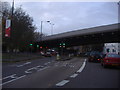
Hammersmith Flyover at junction to A4 westbound
Image: © David Howard
Taken: 16 Nov 2008
0.02 miles
6
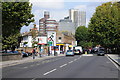
Hammersmith Bridge Road
Hammersmith Bridge Road to the north of the River Thames and Hammersmith Bridge.
Image: © Philip Halling
Taken: 24 Sep 2011
0.05 miles
10
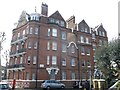
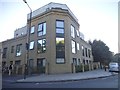
Digby Mansions, Hammersmith
This large block of apartments is on Hammersmith Bridge Road.
Seen at the junction with Rutland Grove.
Image: © David Anstiss
Taken: 14 Apr 2013
0.06 miles