IMAGES TAKEN NEAR TO
Field Road, LONDON, W6 8HW
Introduction
This page details the photographs taken nearby to Field Road, W6 8HW by members of the Geograph project.
The Geograph project started in 2005 with the aim of publishing, organising and preserving representative images for every square kilometre of Great Britain, Ireland and the Isle of Man.

There are currently over 7.5m images from over14,400 individuals and you can help contribute to the project by visiting https://www.geograph.org.uk
Image Map
Images are licensed for reuse under creativecommons.org/licenses/by-sa/2.0
Notes
- Clicking on the map will re-center to the selected point.
- The higher the marker number, the further away the image location is from the centre of the postcode.
Image Listing (191 Images Found)
Images are licensed for reuse under creativecommons.org/licenses/by-sa/2.0
Image
Details
Distance
1
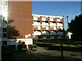
Horton House, Field Road, W6
Part of the Field Road Council estate, W6.
Image: © Phillip Perry
Taken: 26 Jun 2008
0.01 miles
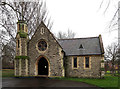
5
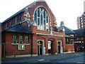
St. Alban's Church, W6
In Margravine Road, W6.
Image: © Phillip Perry
Taken: 26 Jun 2008
0.07 miles
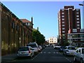
7

Looking towards the J. Lyons & Co. War Memorial in Margravine Cemetery
On 7 October 2002 the war memorials of J. Lyons & Co. were rededicated, after having been relocated to Margravine Cemetery.
Image: © Marathon
Taken: 23 Mar 2011
0.08 miles
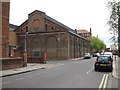
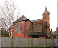
8

The Pear Tree Public House
The pub is to be found in Margravine Road, not far from Barons Court Tube station.
Image: © Marathon
Taken: 23 Mar 2011
0.08 miles
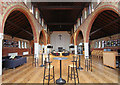
10
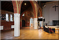
St Alban, Margravine Road - North arcade
Image: © John Salmon
Taken: 31 Jan 2017
0.08 miles